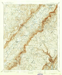
1910 Map of Sequatchie Valley
USGS Topo · Published 1937About this map
Pikeville serves as the focal point of this 1908–1909 survey, situated along the Sequatchie River where the Nashville Chattanooga and St Louis Railway corridor defines the valley's economy. The landscape is characterized by a dense network of mills and mountain gaps, revealing the era's reliance on water power and strategic passage through the Cumberland Plateau. Industry is evident at Tollett Mill, Mansfield Mill, and Hembree Mill, while the social fabric of Bledsoe County is traced through sites like Locust Grove Church and Beaver Hill School. Unique terrain features such as The Penitentiary and Devils Racepath highlight the complex topography surrounding the central valley. From the post office at Melvine PO to the resort character of Saratoga Springs, the map captures a moment of transition where established rural communities navigated the steep ridges of East Tennessee.
Find a feature on this map
104 named features on this map. Tap any name to fly to it.
Don’t see what you’re looking for? This feature index may not catch every label — zoom into the map to look around manually.
Map Details
Editions of this 1910 Sequatchie Valley Map
2 editions found

Other maps of this area

1886 · Cleveland
USGS Topo · 1:125,000

1887 · Kingston
USGS Topo · 1:125,000

1888 · Chattanooga
USGS Topo · 1:125,000

1891 · Kingston
USGS Topo · 1:125,000

1892 · Pikeville
USGS Topo · 1:125,000

1892 · Cleveland
USGS Topo · 1:125,000

1893 · Chattanooga
USGS Topo · 1:125,000

1893 · Kingston
USGS Topo · 1:125,000

1895 · Cleveland
USGS Topo · 1:125,000

1895 · Pikeville
USGS Topo · 1:125,000