1940s Maps of Saint Andrews, Tennessee
Explore 1 historic maps of Saint Andrews from the 1940s. These maps offer a rare glimpse into what life looked like during the 1940s — showing old roads, neighborhoods, homes, and landmarks that have changed or disappeared over time.
Whether you're researching your family's past, planning a metal detecting trip, or studying how Saint Andrews's landscape evolved across the 1940s, these high-resolution maps are a powerful tool for exploring the history of this region.
- Focus on a specific era: All maps on this page are from the 1940s, giving you a focused view of this time period.
- See what’s changed: Compare century-old streets, trails, and buildings to today's modern landscape using overlays and satellite layers.
- Research with precision: Use these maps for genealogy, historical research, land use analysis, or educational projects.
- View, download, or print: Maps are fully viewable online in high resolution, and can be downloaded or printed for your own records.
Start exploring Saint Andrews's history through authentic maps from the 1940s. This is your window into the past.
Saint Andrews, TN maps
(1)- 1946 Map of Sewanee, 1947 Print
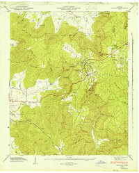 1946 Sewanee1947 Print · USGSSewanee and the surrounding plateau heights are captured here just after the war, showing the deep connection between the university and the mountain. Genealogists and historians can trace rail history at the Cowan Tunnel or locate family plots at Harrison Cem and St Marys Cem.4 unique versions available
End of results
Showing maps 1-1 of 1
Top cities near Saint Andrews
- Manchester historical maps
- Winchester historical maps
- South Pittsburg historical maps
- Sewanee historical maps
- Estill Springs historical maps
- Bridgeport historical maps
See more
Frequently asked questions
- What are the different types of historical maps available for Saint Andrews?
- What is the oldest map of Saint Andrews?
- Where can I purchase historical maps of Saint Andrews for my home or office?
- Where can I download high-res historical maps of Saint Andrews?
- Are there historical topographic maps available for Saint Andrews?
- Is there historical aerial imagery available for Saint Andrews?
- Where are historical maps of Saint Andrews sourced from?