1960s Maps of Rutherford, Tennessee
Explore 2 historic maps of Rutherford from the 1960s. These maps offer a rare glimpse into what life looked like during the 1960s — showing old roads, neighborhoods, homes, and landmarks that have changed or disappeared over time.
Whether you're researching your family's past, planning a metal detecting trip, or studying how Rutherford's landscape evolved across the 1960s, these high-resolution maps are a powerful tool for exploring the history of this region.
- Focus on a specific era: All maps on this page are from the 1960s, giving you a focused view of this time period.
- See what’s changed: Compare century-old streets, trails, and buildings to today's modern landscape using overlays and satellite layers.
- Research with precision: Use these maps for genealogy, historical research, land use analysis, or educational projects.
- View, download, or print: Maps are fully viewable online in high resolution, and can be downloaded or printed for your own records.
Start exploring Rutherford's history through authentic maps from the 1960s. This is your window into the past.
Rutherford, TN maps
(2)- 1964 Map of Yorkville, 1967 Print
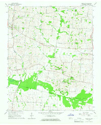 1964 Yorkville1967 Print · USGSMid-century West Tennessee comes to life here as agricultural communities like Yorkville and Hopewell thrive along the winding North Fork Forked Deer River. Genealogists can trace family footprints across several burial sites and rural steeples, including Flowers Cem, Bethel Cem, and Mt Olive Ch.2 unique versions available
 - 1965 Map of Kenton, 1966 Print
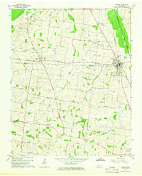 1965 Kenton1966 Print · USGSThe West Tennessee borderlands of Obion and Gibson counties are captured here in the mid-sixties, centered on the railroad town of Kenton. Local historians can trace old community hubs like Mason Hall, Tyson Store, and family landmarks including Sunny Side Cem.2 unique versions available
End of results
Showing maps 1-2 of 2
Top cities near Rutherford
- Martin historical maps
- Trenton historical maps
- Dyer historical maps
- Greenfield historical maps
- Troy historical maps
- Obion historical maps
See more
Frequently asked questions
- What are the different types of historical maps available for Rutherford?
- What is the oldest map of Rutherford?
- Where can I purchase historical maps of Rutherford for my home or office?
- Where can I download high-res historical maps of Rutherford?
- Are there historical topographic maps available for Rutherford?
- Is there historical aerial imagery available for Rutherford?
- Where are historical maps of Rutherford sourced from?