1900s (20th Century) Maps of Lynnville, Tennessee
Explore 10 historic maps of Lynnville from the 1900s (20th Century). These maps offer a rare glimpse into what life looked like during the 1900s — showing old roads, neighborhoods, homes, and landmarks that have changed or disappeared over time.
Whether you're researching your family's past, planning a metal detecting trip, or studying how Lynnville's landscape evolved across the 1900s, these high-resolution maps are a powerful tool for exploring the history of this region.
- Focus on a specific era: All maps on this page are from the 1900s, giving you a focused view of this time period.
- See what’s changed: Compare century-old streets, trails, and buildings to today's modern landscape using overlays and satellite layers.
- Research with precision: Use these maps for genealogy, historical research, land use analysis, or educational projects.
- View, download, or print: Maps are fully viewable online in high resolution, and can be downloaded or printed for your own records.
Start exploring Lynnville's history through authentic maps from the 1900s. This is your window into the past.
Lynnville, TN maps
(10)- 1936 Map of Milky Way
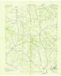
 1936 Milky Way1936 Print · USGSGiles County in the mid-1930s is a landscape of established estates and railroad-dependent hamlets. Researchers can trace family history through numerous landmarks like Milky Way Farm, Riversburg Station, and the Morris Town Cem.
 - 1936 Map of Campbells Station
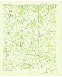 1936 Campbells Station1936 Print · USGSThe rural borderlands of Maury, Marshall, and Giles counties come into focus during the mid-thirties, centered on the Louisville and Nashville rail line. Researchers can trace old family sites and rural centers like Campbells Station, the Ballamfant Cem, and Mooresville Sch.
 - 1936 Map of Lynnville
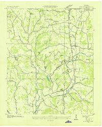
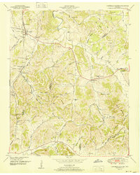
 1936 Lynnville1936 Print · USGSThe hills of Giles and Maury counties are captured here in the mid-1930s as the local phosphate industry was active. Genealogists can locate family-named landmarks and institutions like Chaffin Cem, Gipsonville Sch, and the Phosphate Mines.
 - 1949 Map of Campbells Station, 1982 Print
 1949 Campbells Station1982 Print · USGSMid-century Tennessee hill country comes alive here as the LOUISVILLE AND NASHVILLE railroad winds through the ridges of Maury and Marshall counties. Genealogists and historians can trace family landholdings via dozens of sites like Shahe Cem, Mooresville School, and Dodson Siding.
 - 1951 Map of Campbells Station
 1951 Campbells Station1951 Print · USGSThe hills of Maury and Marshall counties are captured here in the early fifties, showing the rural communities along the Louisville and Nashville railroad. Genealogists can locate numerous family burial grounds and community hubs like Culleoka, Lowery Chapel, and the Mooresville School.3 unique versions available
 - 1951 Map of Milky Way, 1954 Print
 1951 Milky Way1954 Print · USGSGiles County at the mid-century reveals a rural landscape anchored by rail and river. Genealogists can trace family names through dozens of landmarks like Abernathy Cem, Lilburn Sch, and the community of Riversburg.2 unique versions available
 - 1951 Map of Lynnville, 1956 Print
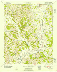
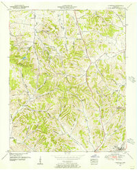 1951 Lynnville1956 Print · USGSThe hills of Middle Tennessee are captured here in the early 1950s, showing the ridge-and-hollow terrain along the Maury and Giles County line. Researchers can locate numerous family cemeteries and remote churches like Taylor Chapel and the Old Camping Ground Cemetery.2 unique versions available
 - 1956 Map of Columbia, 1960 Print
 1956 Columbia1960 Print · USGSMiddle Tennessee in the mid-fifties presents a landscape of established river towns and critical rail hubs before the arrival of the modern interstate system. Researchers can trace the routes of the Louisville and Nashville railroad or locate historic landmarks like Stones River National Military Park and the Tennessee National Wildlife Refuge.6 unique versions available
 - 1981 Map of Tullahoma, 1982 Print
 1981 Tullahoma1982 Print · USGSSouthern Tennessee enters the 1980s with a mix of aerospace technology and deep rural roots. Researchers can trace the L & N RR through Shelbyville and Fayetteville or locate family sites like Old Salem Cem and Blanton Chapel near the Cumberland Plateau.
 - 1985 Map of Lawrenceburg
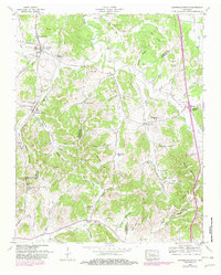
 1985 Lawrenceburg1985 Print · USGSMiddle Tennessee and Northern Alabama are captured in the mid-1980s, showcasing a landscape of high ridges and winding river valleys. Genealogists and historians can trace rail lines like the Seaboard System Railroad or locate community landmarks such as Saint Marys Church and Three Churches.2 unique versions available
End of results
Showing maps 1-10 of 10
Top cities near Lynnville
- Columbia historical maps
- Lewisburg historical maps
- Pulaski historical maps
- Mount Pleasant historical maps
- Cornersville historical maps
Frequently asked questions
- What are the different types of historical maps available for Lynnville?
- What is the oldest map of Lynnville?
- Where can I purchase historical maps of Lynnville for my home or office?
- Where can I download high-res historical maps of Lynnville?
- Are there historical topographic maps available for Lynnville?
- Is there historical aerial imagery available for Lynnville?
- Where are historical maps of Lynnville sourced from?