1930s Maps of Lynnville, Tennessee
Explore 3 historic maps of Lynnville from the 1930s. These maps offer a rare glimpse into what life looked like during the 1930s — showing old roads, neighborhoods, homes, and landmarks that have changed or disappeared over time.
Whether you're researching your family's past, planning a metal detecting trip, or studying how Lynnville's landscape evolved across the 1930s, these high-resolution maps are a powerful tool for exploring the history of this region.
- Focus on a specific era: All maps on this page are from the 1930s, giving you a focused view of this time period.
- See what’s changed: Compare century-old streets, trails, and buildings to today's modern landscape using overlays and satellite layers.
- Research with precision: Use these maps for genealogy, historical research, land use analysis, or educational projects.
- View, download, or print: Maps are fully viewable online in high resolution, and can be downloaded or printed for your own records.
Start exploring Lynnville's history through authentic maps from the 1930s. This is your window into the past.
Lynnville, TN maps
(3)- 1936 Map of Milky Way
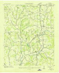 1936 Milky Way1936 Print · USGSGiles County in the mid-1930s is a landscape of established estates and railroad-dependent hamlets. Researchers can trace family history through numerous landmarks like Milky Way Farm, Riversburg Station, and the Morris Town Cem.
 - 1936 Map of Campbells Station
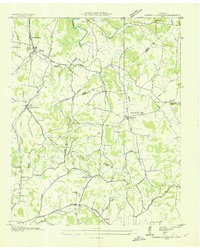 1936 Campbells Station1936 Print · USGSThe rural borderlands of Maury, Marshall, and Giles counties come into focus during the mid-thirties, centered on the Louisville and Nashville rail line. Researchers can trace old family sites and rural centers like Campbells Station, the Ballamfant Cem, and Mooresville Sch.
 - 1936 Map of Lynnville
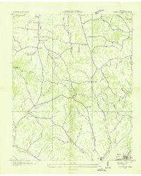 1936 Lynnville1936 Print · USGSThe hills of Giles and Maury counties are captured here in the mid-1930s as the local phosphate industry was active. Genealogists can locate family-named landmarks and institutions like Chaffin Cem, Gipsonville Sch, and the Phosphate Mines.
End of results
Showing maps 1-3 of 3
Top cities near Lynnville
- Columbia historical maps
- Lewisburg historical maps
- Pulaski historical maps
- Mount Pleasant historical maps
- Cornersville historical maps
Frequently asked questions
- What are the different types of historical maps available for Lynnville?
- What is the oldest map of Lynnville?
- Where can I purchase historical maps of Lynnville for my home or office?
- Where can I download high-res historical maps of Lynnville?
- Are there historical topographic maps available for Lynnville?
- Is there historical aerial imagery available for Lynnville?
- Where are historical maps of Lynnville sourced from?