1940s Maps of Rutledge, Tennessee
Explore 2 historic maps of Rutledge from the 1940s. These maps offer a rare glimpse into what life looked like during the 1940s — showing old roads, neighborhoods, homes, and landmarks that have changed or disappeared over time.
Whether you're researching your family's past, planning a metal detecting trip, or studying how Rutledge's landscape evolved across the 1940s, these high-resolution maps are a powerful tool for exploring the history of this region.
- Focus on a specific era: All maps on this page are from the 1940s, giving you a focused view of this time period.
- See what’s changed: Compare century-old streets, trails, and buildings to today's modern landscape using overlays and satellite layers.
- Research with precision: Use these maps for genealogy, historical research, land use analysis, or educational projects.
- View, download, or print: Maps are fully viewable online in high resolution, and can be downloaded or printed for your own records.
Start exploring Rutledge's history through authentic maps from the 1940s. This is your window into the past.
Rutledge, TN maps
(2)- 1941 Map of Dutch Valley, 1963 Print
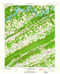 1941 Dutch Valley1963 Print · USGSGrainger County is captured here in the early 1940s, just as the regional landscape was being reshaped by the Clinch River Reservoir. Genealogists and historians can locate numerous family sites like Bunchtown Cem and Rooker Cem alongside rural landmarks like Beeler Mill and Noe Chapel Sch.4 unique versions available
 - 1942 Map of Dutch Valley
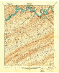 1942 Dutch Valley1942 Print · USGSEastern Tennessee at the start of the 1940s reveals a landscape of tight-knit valley communities and rugged ridges. Researchers can locate dozens of family cemeteries like Kitts Cem and schools such as Dutch Valley Sch along the Southern Railway.
End of results
Showing maps 1-2 of 2
Top cities near Rutledge
- Knoxville historical maps
- Morristown historical maps
- Jefferson City historical maps
- Maynardville historical maps
- Bean Station historical maps
- New Tazewell historical maps
See more
Top neighborhoods of Rutledge
Frequently asked questions
- What are the different types of historical maps available for Rutledge?
- What is the oldest map of Rutledge?
- Where can I purchase historical maps of Rutledge for my home or office?
- Where can I download high-res historical maps of Rutledge?
- Are there historical topographic maps available for Rutledge?
- Is there historical aerial imagery available for Rutledge?
- Where are historical maps of Rutledge sourced from?