1930s Maps of Water Fork Mill, Tennessee
Explore 2 historic maps of Water Fork Mill from the 1930s. These maps offer a rare glimpse into what life looked like during the 1930s — showing old roads, neighborhoods, homes, and landmarks that have changed or disappeared over time.
Whether you're researching your family's past, planning a metal detecting trip, or studying how Water Fork Mill's landscape evolved across the 1930s, these high-resolution maps are a powerful tool for exploring the history of this region.
- Focus on a specific era: All maps on this page are from the 1930s, giving you a focused view of this time period.
- See what’s changed: Compare century-old streets, trails, and buildings to today's modern landscape using overlays and satellite layers.
- Research with precision: Use these maps for genealogy, historical research, land use analysis, or educational projects.
- View, download, or print: Maps are fully viewable online in high resolution, and can be downloaded or printed for your own records.
Start exploring Water Fork Mill's history through authentic maps from the 1930s. This is your window into the past.
Water Fork Mill, TN maps
(2)- 1936 Map of Greystone
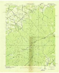 1936 Greystone1936 Print · USGSThe Tennessee and North Carolina borderlands in the mid-1930s reveal a landscape of mountain mills and remote forest settlements. Researchers can trace early family sites like Jennings, visit rural centers like Gethsemane Ch, or locate old industrial sites like Water Fork Mill.
 - 1939 Map of Greystone
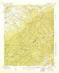 1939 Greystone1939 Print · USGSThe Tennessee and North Carolina borderlands come into focus in the late 1930s, showing a landscape of high ridges and isolated mountain hollows. Genealogists and hikers can trace the Appalachian Trail past family landmarks like Doak Cabin, Shelton Mission, and Dobson Sch.7 unique versions available
End of results
Showing maps 1-2 of 2
Top cities near Water Fork Mill
- Johnson City historical maps
- Greeneville historical maps
- Tusculum historical maps
- Mosheim historical maps
- Hot Springs historical maps
- Baileyton historical maps
Frequently asked questions
- What are the different types of historical maps available for Water Fork Mill?
- What is the oldest map of Water Fork Mill?
- Where can I purchase historical maps of Water Fork Mill for my home or office?
- Where can I download high-res historical maps of Water Fork Mill?
- Are there historical topographic maps available for Water Fork Mill?
- Is there historical aerial imagery available for Water Fork Mill?
- Where are historical maps of Water Fork Mill sourced from?