1940s Maps of East Ridge, Tennessee
Explore 6 historic maps of East Ridge from the 1940s. These maps offer a rare glimpse into what life looked like during the 1940s — showing old roads, neighborhoods, homes, and landmarks that have changed or disappeared over time.
Whether you're researching your family's past, planning a metal detecting trip, or studying how East Ridge's landscape evolved across the 1940s, these high-resolution maps are a powerful tool for exploring the history of this region.
- Focus on a specific era: All maps on this page are from the 1940s, giving you a focused view of this time period.
- See what’s changed: Compare century-old streets, trails, and buildings to today's modern landscape using overlays and satellite layers.
- Research with precision: Use these maps for genealogy, historical research, land use analysis, or educational projects.
- View, download, or print: Maps are fully viewable online in high resolution, and can be downloaded or printed for your own records.
Start exploring East Ridge's history through authentic maps from the 1940s. This is your window into the past.
East Ridge, TN maps
(6)- 1940 Map of Chattanooga
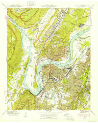 1940 Chattanooga1940 Print · USGSChattanooga and the Tennessee River valley are captured here at the dawn of the 1940s, showcasing a bustling rail and river hub. Researchers can trace the legacy of Union Station, find family plots in National Cem, or locate the historic Cravens House on the slopes of Lookout Mountain.2 unique versions available
 - 1941 Map of Chattanooga
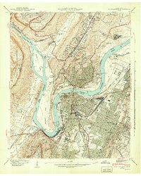 1941 Chattanooga1941 Print · USGSChattanooga was a powerhouse of rail and river industry just before the Second World War. Genealogists and historians can trace the early city grid from Union Station to MISSIONARY RIDGE, locating landmarks like Ruby Falls and National Cem.5 unique versions available
 - 1942 Map of East Chattanooga
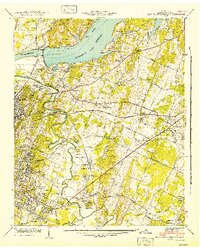 1942 East Chattanooga1942 Print · USGSHamilton County's river landscape underwent massive changes during the early Forties as the Tennessee Valley Authority completed the Chickamauga Dam. Genealogists can trace family roots through the Silverdale Confederate Cem, Brainerd Cem, and numerous rural schools like Jersey Sch.2 unique versions available
 - 1942 Map of Fort Oglethorpe, 1946 Print
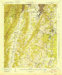 1942 Fort Oglethorpe1946 Print · USGSThe Tennessee-Georgia borderlands are captured here during the early 1940s, highlighting the transition from historic battlefields to growing residential communities. Genealogists and historians can trace family-named sites like Snodgrass House, McCallie Lake, and Lee and Gordon Mill.3 unique versions available
 - 1943 Map of East Ridge, 1957 Print
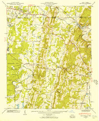 1943 East Ridge1957 Print · USGSThe Tennessee-Georgia borderlands come to life in the 1940s as a landscape of rural schools, family cemeteries, and military reservations. Genealogists can trace family roots through Lomenick Cem, Boynton, and landmarks like Burning Bush Sch.
 - 1946 Map of East Ridge, 1947 Print
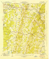 1946 East Ridge1947 Print · USGSThe Tennessee and Georgia borderlands come alive in the mid-forties as postwar expansion reaches into the ridges south of Chattanooga. Genealogists and historians can trace family sites like Newnan Spring Cem, old landmarks like Swanson Mill, and the early footprint of Lake Winnepesaukah.2 unique versions available
End of results
Showing maps 1-6 of 6
Top cities near East Ridge
- Chattanooga historical maps
- Dalton historical maps
- East Ridge historical maps
- Soddy-Daisy historical maps
- Fort Oglethorpe historical maps
- Collegedale historical maps
See more
Top neighborhoods of East Ridge
- Poindexter Heights historical maps
- Blaney Forest historical maps
- Claremont historical maps
- Lansdell Park historical maps
- Mana Estates historical maps
- Walnut Hills historical maps
See more
Frequently asked questions
- What are the different types of historical maps available for East Ridge?
- What is the oldest map of East Ridge?
- Where can I purchase historical maps of East Ridge for my home or office?
- Where can I download high-res historical maps of East Ridge?
- Are there historical topographic maps available for East Ridge?
- Is there historical aerial imagery available for East Ridge?
- Where are historical maps of East Ridge sourced from?