1930s Maps of Signal Mountain, Tennessee
Explore 3 historic maps of Signal Mountain from the 1930s. These maps offer a rare glimpse into what life looked like during the 1930s — showing old roads, neighborhoods, homes, and landmarks that have changed or disappeared over time.
Whether you're researching your family's past, planning a metal detecting trip, or studying how Signal Mountain's landscape evolved across the 1930s, these high-resolution maps are a powerful tool for exploring the history of this region.
- Focus on a specific era: All maps on this page are from the 1930s, giving you a focused view of this time period.
- See what’s changed: Compare century-old streets, trails, and buildings to today's modern landscape using overlays and satellite layers.
- Research with precision: Use these maps for genealogy, historical research, land use analysis, or educational projects.
- View, download, or print: Maps are fully viewable online in high resolution, and can be downloaded or printed for your own records.
Start exploring Signal Mountain's history through authentic maps from the 1930s. This is your window into the past.
Signal Mountain, TN maps
(3)- 1936 Map of Ketner Gap
 1936 Ketner Gap1936 Print · USGSMarion and Sequatchie counties appear in the mid-1930s as a landscape of isolated coal mines and ridge-top gaps. Genealogists and historians can trace family locations through Grayson Cem, Sulphur Springs Sch, and the industrial sites at Barnes Mine.
 - 1936 Map of Fairmount
 1936 Fairmount1936 Print · USGSThe plateau communities of Walden Ridge are captured here in the mid-1930s as modern infrastructure reached these mountain settlements. Genealogists can trace family footprints through numerous landmarks like Sawyer Cem, Fairmount Sch, and Union Springs Ch.
 - 1936 Map of Chattanooga
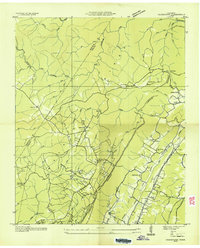
 1936 Chattanooga1936 Print · USGSChattanooga and the Tennessee River are shown here in the mid-thirties as the river valley underwent massive transformation. Trace the historic street grid and landmarks like the Incline Railway, National Cem, and Moccasin Bend.
End of results
Showing maps 1-3 of 3
Top cities near Signal Mountain
- Chattanooga historical maps
- East Ridge historical maps
- East Ridge historical maps
- Soddy-Daisy historical maps
- Fort Oglethorpe historical maps
- Dunlap historical maps
See more
Top neighborhoods of Signal Mountain
- Applewood historical maps
- Birnam Wood historical maps
- Hiddenbrook historical maps
- Shepherd Forest historical maps
- Signal Terrace historical maps
- Timberlinks historical maps
See more
Frequently asked questions
- What are the different types of historical maps available for Signal Mountain?
- What is the oldest map of Signal Mountain?
- Where can I purchase historical maps of Signal Mountain for my home or office?
- Where can I download high-res historical maps of Signal Mountain?
- Are there historical topographic maps available for Signal Mountain?
- Is there historical aerial imagery available for Signal Mountain?
- Where are historical maps of Signal Mountain sourced from?