1960s Maps of Signal Mountain, Tennessee
Explore 4 historic maps of Signal Mountain from the 1960s. These maps offer a rare glimpse into what life looked like during the 1960s — showing old roads, neighborhoods, homes, and landmarks that have changed or disappeared over time.
Whether you're researching your family's past, planning a metal detecting trip, or studying how Signal Mountain's landscape evolved across the 1960s, these high-resolution maps are a powerful tool for exploring the history of this region.
- Focus on a specific era: All maps on this page are from the 1960s, giving you a focused view of this time period.
- See what’s changed: Compare century-old streets, trails, and buildings to today's modern landscape using overlays and satellite layers.
- Research with precision: Use these maps for genealogy, historical research, land use analysis, or educational projects.
- View, download, or print: Maps are fully viewable online in high resolution, and can be downloaded or printed for your own records.
Start exploring Signal Mountain's history through authentic maps from the 1960s. This is your window into the past.
Signal Mountain, TN maps
(4)- 1960 Map of Chattanooga
 1960 Chattanooga1960 Print · USGSSoutheast Tennessee and the southern Appalachians are shown here at the height of the river-management era. You can trace the valley rail lines and locate Lookout Mountain and the expansive waters of Chickamauga Reservoir.
 - 1964 Map of Chattanooga
 1964 Chattanooga1964 Print · USGSSoutheast Tennessee and the western Carolinas appear in the mid-sixties as a powerhouse of river-driven industry and mountain wilderness. Genealogists and historians can trace rail-town lineages along the Southern Ry or locate family landmarks near Watts Bar Lake and Tellico Plains.
 - 1969 Map of Chattanooga
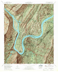 1969 Chattanooga1969 Print · USGSChattanooga and the Tennessee River valley are captured in the late sixties as new interstate construction began to cut through the city's historic core. Trace the layout of the National Cemetery, the rail lines at Cravens Yards, and the unique development of Moccasin Bend.6 unique versions available
 - 1969 Map of Fairmount, 1972 Print
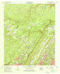 1969 Fairmount1972 Print · USGSHamilton County uplands and the Chattanooga valley come into focus during the late sixties as suburban growth climbs the ridges. Trace family history through Sawyer Cem and Brown Chapel Cem, or locate landmarks like the Wines T Thrasher School and Falling Water Falls.5 unique versions available
End of results
Showing maps 1-4 of 4
Top cities near Signal Mountain
- Chattanooga historical maps
- East Ridge historical maps
- East Ridge historical maps
- Soddy-Daisy historical maps
- Fort Oglethorpe historical maps
- Dunlap historical maps
See more
Top neighborhoods of Signal Mountain
- Applewood historical maps
- Birnam Wood historical maps
- Hiddenbrook historical maps
- Shepherd Forest historical maps
- Signal Terrace historical maps
- Timberlinks historical maps
See more
Frequently asked questions
- What are the different types of historical maps available for Signal Mountain?
- What is the oldest map of Signal Mountain?
- Where can I purchase historical maps of Signal Mountain for my home or office?
- Where can I download high-res historical maps of Signal Mountain?
- Are there historical topographic maps available for Signal Mountain?
- Is there historical aerial imagery available for Signal Mountain?
- Where are historical maps of Signal Mountain sourced from?