1950s Maps of Hancock County, Tennessee
Explore 5 historic maps of Hancock County from the 1950s. These maps offer a rare glimpse into what life looked like during the 1950s — showing old roads, neighborhoods, homes, and landmarks that have changed or disappeared over time.
Whether you're researching your family's past, planning a metal detecting trip, or studying how Hancock County's landscape evolved across the 1950s, these high-resolution maps are a powerful tool for exploring the history of this region.
- Focus on a specific era: All maps on this page are from the 1950s, giving you a focused view of this time period.
- See what’s changed: Compare century-old streets, trails, and buildings to today's modern landscape using overlays and satellite layers.
- Research with precision: Use these maps for genealogy, historical research, land use analysis, or educational projects.
- View, download, or print: Maps are fully viewable online in high resolution, and can be downloaded or printed for your own records.
Start exploring Hancock County's history through authentic maps from the 1950s. This is your window into the past.
Hancock County, TN maps
(5)- 1950 Map of Colemen Gap
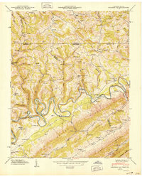 1950 Colemen Gap1950 Print · USGSThe Tennessee-Virginia state line follows the high ridges and winding river bends of the Appalachian borderlands just after the war. Researchers can locate family landmarks such as Yeary Mill, trace the Powell River through the Narrows, and find remote schools like Hoop Creek Sch.
 - 1950 Map of Kyles Ford
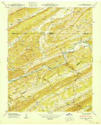 1950 Kyles Ford1950 Print · USGSHancock County life in the mid-century is centered on the winding Clinch River and the rugged ridges of East Tennessee and Southwest Virginia. Researchers can locate family landmarks like Livesay Mill and numerous burial grounds including Testerman Cem and Sizemore Cem.
 - 1950 Map of Looneys Gap
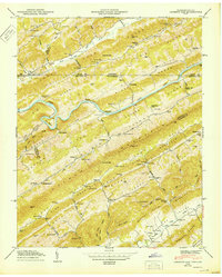 1950 Looneys Gap1950 Print · USGSThe Tennessee-Virginia borderlands in the 1940s are characterized by the steep ridges of Clinch Mountain and the deep bends of the Clinch River. Researchers can trace old mountain life through family sites like Sizemore Cem and rural schools like Wake Forest School.
 - 1955 Map of Johnson City
 1955 Johnson City1955 Print · USGSEast Tennessee and the bordering highlands of Virginia and Kentucky appear here during the post-war industrial boom. You can trace the complex network of mountain ridges and new TVA lakes, from Johnson City to the coalfields near Middlesboro and Lynch.
 - 1957 Map of Johnson City, 1966 Print
 1957 Johnson City1966 Print · USGSUpper East Tennessee and Southwest Virginia are shown here during the mid-sixties transition of the Appalachians. Researchers can trace the industrial rail hubs of Kingsport, the sprawling waters of Cherokee Lake, and the historic Cumberland Gap.
End of results
Showing maps 1-5 of 5
Top cities of Hancock County
Frequently asked questions
- What are the different types of historical maps available for Hancock County?
- What is the oldest map of Hancock County?
- Where can I purchase historical maps of Hancock County for my home or office?
- Where can I download high-res historical maps of Hancock County?
- Are there historical topographic maps available for Hancock County?
- Is there historical aerial imagery available for Hancock County?
- Where are historical maps of Hancock County sourced from?