1960s Maps of Shaw, Tennessee
Explore 1 historic maps of Shaw from the 1960s. These maps offer a rare glimpse into what life looked like during the 1960s — showing old roads, neighborhoods, homes, and landmarks that have changed or disappeared over time.
Whether you're researching your family's past, planning a metal detecting trip, or studying how Shaw's landscape evolved across the 1960s, these high-resolution maps are a powerful tool for exploring the history of this region.
- Focus on a specific era: All maps on this page are from the 1960s, giving you a focused view of this time period.
- See what’s changed: Compare century-old streets, trails, and buildings to today's modern landscape using overlays and satellite layers.
- Research with precision: Use these maps for genealogy, historical research, land use analysis, or educational projects.
- View, download, or print: Maps are fully viewable online in high resolution, and can be downloaded or printed for your own records.
Start exploring Shaw's history through authentic maps from the 1960s. This is your window into the past.
Shaw, TN maps
(1)- 1964 Map of Tibbs, 1965 Print
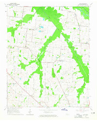 1964 Tibbs1965 Print · USGSHaywood County in the mid-sixties reveals a rural landscape of scattered hamlets and family-named schools before modern consolidation. Genealogists can trace the locations of Antioch Ch, Woodlawn Cem, and early educational sites like Hickory Grove Sch.2 unique versions available
End of results
Showing maps 1-1 of 1
Top cities near Shaw
- Brownsville historical maps
- Ripley historical maps
- Alamo historical maps
- Halls historical maps
- Henning historical maps
- Gates historical maps
See more
Frequently asked questions
- What are the different types of historical maps available for Shaw?
- What is the oldest map of Shaw?
- Where can I purchase historical maps of Shaw for my home or office?
- Where can I download high-res historical maps of Shaw?
- Are there historical topographic maps available for Shaw?
- Is there historical aerial imagery available for Shaw?
- Where are historical maps of Shaw sourced from?