1950s Maps of Houston County, Tennessee
Explore 7 historic maps of Houston County from the 1950s. These maps offer a rare glimpse into what life looked like during the 1950s — showing old roads, neighborhoods, homes, and landmarks that have changed or disappeared over time.
Whether you're researching your family's past, planning a metal detecting trip, or studying how Houston County's landscape evolved across the 1950s, these high-resolution maps are a powerful tool for exploring the history of this region.
- Focus on a specific era: All maps on this page are from the 1950s, giving you a focused view of this time period.
- See what’s changed: Compare century-old streets, trails, and buildings to today's modern landscape using overlays and satellite layers.
- Research with precision: Use these maps for genealogy, historical research, land use analysis, or educational projects.
- View, download, or print: Maps are fully viewable online in high resolution, and can be downloaded or printed for your own records.
Start exploring Houston County's history through authentic maps from the 1950s. This is your window into the past.
Houston County, TN maps
(7)- 1950 Map of Halls Creek, 1953 Print
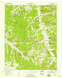
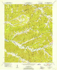 1950 Halls Creek1953 Print · USGSHumphreys and Houston Counties appear here in the early fifties, showing a rural landscape shaped by the new waters of Kentucky Lake. Genealogists can trace family landmarks and schools like Elizabeth Sch or find ancestral sites at Beecham Cem and Shiloh Cem.3 unique versions available
 - 1950 Map of Stewart, 1953 Print
 1950 Stewart1953 Print · USGSThe Tennessee and Kentucky borderlands come alive in this mid-century portrait of the ridge-and-hollow country before modern expansion. Researchers can trace the Louisville and Nashville rail line through old Stewart and locate family burial grounds like McIntosh Cem or the Abandoned limekiln.3 unique versions available
 - 1950 Map of Mc Kinnon, 1954 Print
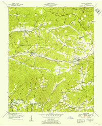
 1950 Mc Kinnon1954 Print · USGSThe Tennessee River valley is shown shortly after the creation of Kentucky Lake, when the rising waters reshaped local life. Genealogists and historians can trace numerous family burial sites like Wynns Cem and rail-era landmarks such as the Louisville and Nashville line and McKinnon.3 unique versions available
 - 1952 Map of Woolworth, 1957 Print
 1952 Woolworth1957 Print · USGSThe rural Tennessee backcountry along the Houston and Humphreys County line is captured here in the early fifties. Genealogists and researchers can trace family roots through numerous landmarks like Batson Cem, Mt Olivet Hill Sch, and Woolworth.3 unique versions available
 - 1953 Map of Ruskin, 1958 Print
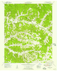
 1953 Ruskin1958 Print · USGSThe rural borders of Dickson, Houston, and Humphreys counties are captured here in the early fifties, showing a landscape defined by deep hollows and high ridges. Family researchers can locate dozens of remote burial sites like Dotson Cem and Yates Cem, alongside crossroads communities like Ruskin and Thompsons Crossroads.3 unique versions available
 - 1956 Map of Nashville, 1971 Print
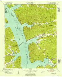
 1956 Nashville1971 Print · USGSThe Tennessee-Kentucky borderlands come into focus in the mid-1960s as major reservoir projects transformed the Cumberland and Tennessee river valleys. Researchers can trace the rail networks of the Louisville and Nashville and visit sites like Fort Campbell and Fort Donelson National Military Park.2 unique versions available
 - 1959 Map of Nashville
 1959 Nashville1959 Print · USGSMiddle Tennessee and Southern Kentucky come into focus during the late fifties, showing the region's transition into a modern transportation and military hub. Researchers can trace the sprawling Fort Campbell Military Reservation or locate historic rail stops along the Tennessee Central Ry and Illinois Central RR.
End of results
Showing maps 1-7 of 7
Top cities of Houston County
Frequently asked questions
- What are the different types of historical maps available for Houston County?
- What is the oldest map of Houston County?
- Where can I purchase historical maps of Houston County for my home or office?
- Where can I download high-res historical maps of Houston County?
- Are there historical topographic maps available for Houston County?
- Is there historical aerial imagery available for Houston County?
- Where are historical maps of Houston County sourced from?