1960s Maps of Jackson County, Tennessee
Explore 9 historic maps of Jackson County from the 1960s. These maps offer a rare glimpse into what life looked like during the 1960s — showing old roads, neighborhoods, homes, and landmarks that have changed or disappeared over time.
Whether you're researching your family's past, planning a metal detecting trip, or studying how Jackson County's landscape evolved across the 1960s, these high-resolution maps are a powerful tool for exploring the history of this region.
- Focus on a specific era: All maps on this page are from the 1960s, giving you a focused view of this time period.
- See what’s changed: Compare century-old streets, trails, and buildings to today's modern landscape using overlays and satellite layers.
- Research with precision: Use these maps for genealogy, historical research, land use analysis, or educational projects.
- View, download, or print: Maps are fully viewable online in high resolution, and can be downloaded or printed for your own records.
Start exploring Jackson County's history through authentic maps from the 1960s. This is your window into the past.
Jackson County, TN maps
(9)- 1962 Map of Buffalo Valley, 1964 Print
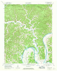
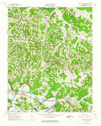 1962 Buffalo Valley1964 Print · USGSUpper Middle Tennessee in the early sixties was a landscape of river-bend bottoms and tight ridge-top settlements. Genealogists and historians can trace family land across Caney Fork and Lancaster, or locate old landmarks like Harris Chapel and Maddux Cem.3 unique versions available
 - 1968 Map of Dodson Branch, 1970 Print
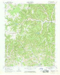
 1968 Dodson Branch1970 Print · USGSJackson County and Putnam County rural life is captured here in the late sixties, just as the new reservoir began to reach into the river valleys. Genealogists can locate family landmarks like Stafford Cem and community hubs such as Dodson Branch Sch and Mount Union.
 - 1968 Map of Willette, 1970 Print
 1968 Willette1970 Print · USGSThe hills of Jackson and Macon counties are shown here in the late sixties just before the landscape was changed by the Cordell Hull Reservoir. Genealogists can trace family sites like Thomas Cem, Hayden, and the Wartrace Sch among the winding hollows.
 - 1968 Map of Burristown, 1970 Print
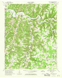
 1968 Burristown1970 Print · USGSThe Cumberland River valley is captured here in the late sixties, just as the Cordell Hull Reservoir was beginning to reshape the Jackson County landscape. Researchers can trace family roots through landmarks like Butlers Landing, Fairview Sch, and Lynn Cem.3 unique versions available
 - 1968 Map of Whitleyville, 1970 Print
 1968 Whitleyville1970 Print · USGSJackson County and Clay County communities are captured here in the late sixties along the winding Cumberland. Trace family roots and local landmarks from Whitleyville to Haydenburg, including Willow Grove Ch and the Draper-Naff Cem.2 unique versions available
 - 1968 Map of Gainesboro, 1970 Print
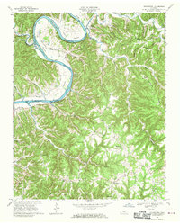
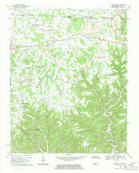
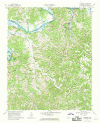 1968 Gainesboro1970 Print · USGSJackson County is shown here in the late sixties, where the winding Cumberland River meets the rural highlands. Local historians can trace family roots through settlements like Nameless and Flynns Lick, or locate the old Poorhouse and Richmond Chapel.3 unique versions available
 - 1968 Map of Granville, 1970 Print
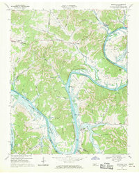 1968 Granville1970 Print · USGSJackson and Smith County river life is captured here as the Cordell Hull Reservoir begins to shape the valley. Trace family sites and land ownership near Granville, Kempville, and the many cemeteries tucked into Stillhouse Hollow.3 unique versions available
 - 1968 Map of Red Boiling Springs, 1971 Print
 1968 Red Boiling Springs1971 Print · USGSThe Tennessee and Kentucky borderlands near Red Boiling Springs are captured here in the late sixties, showing a landscape defined by deep hollows and creek-side settlements. Genealogists can locate family landmarks such as Sadlers Chapel, Leonard Cem, and the community of Hermitage Springs.
 - 1968 Map of Union Hill, 1971 Print
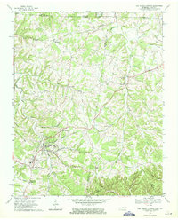
 1968 Union Hill1971 Print · USGSThe Tennessee and Kentucky borderlands near Clay County come to life in this late-1960s survey of upland settlements and winding creek forks. Researchers can trace family sites and community landmarks like Miles Crossroads, Clementsville, and the Mt Vernon Sch.
End of results
Showing maps 1-9 of 9
Top cities of Jackson County
Frequently asked questions
- What are the different types of historical maps available for Jackson County?
- What is the oldest map of Jackson County?
- Where can I purchase historical maps of Jackson County for my home or office?
- Where can I download high-res historical maps of Jackson County?
- Are there historical topographic maps available for Jackson County?
- Is there historical aerial imagery available for Jackson County?
- Where are historical maps of Jackson County sourced from?