1930s Maps of Dandridge, Tennessee
Explore 6 historic maps of Dandridge from the 1930s. These maps offer a rare glimpse into what life looked like during the 1930s — showing old roads, neighborhoods, homes, and landmarks that have changed or disappeared over time.
Whether you're researching your family's past, planning a metal detecting trip, or studying how Dandridge's landscape evolved across the 1930s, these high-resolution maps are a powerful tool for exploring the history of this region.
- Focus on a specific era: All maps on this page are from the 1930s, giving you a focused view of this time period.
- See what’s changed: Compare century-old streets, trails, and buildings to today's modern landscape using overlays and satellite layers.
- Research with precision: Use these maps for genealogy, historical research, land use analysis, or educational projects.
- View, download, or print: Maps are fully viewable online in high resolution, and can be downloaded or printed for your own records.
Start exploring Dandridge's history through authentic maps from the 1930s. This is your window into the past.
Dandridge, TN maps
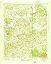
(6)- 1935 Map of English Mountain
 1935 English Mountain1935 Print · USGSSevier County and the foothills of the Smokies are seen here during the mid-thirties as the national park was taking shape. Genealogists can trace family roots through scores of rural institutions like Smoky Mtn Academy, Pittman Center, and the Crockettville Sch.
 - 1935 Map of Shady Grove
 1935 Shady Grove1935 Print · USGSThe French Broad River valley at the border of Jefferson and Sevier counties is documented here just as the Tennessee Valley Authority began its regional work. Researchers can locate Depression-era rural landmarks like Lee Academy, Island Ford Mill, and Roaring Spring.
 - 1935 Map of Jefferson City
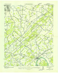 1935 Jefferson City1935 Print · USGSJefferson County in the mid-1930s shows a landscape of river-valley farming and mountain ridges before major Tennessee Valley Authority changes. Genealogists can trace family landmarks like Wesley Chapel, Grants Chapel, and the Cedar Ridge Sch along the French Broad River.
 - 1935 Map of Dandridge
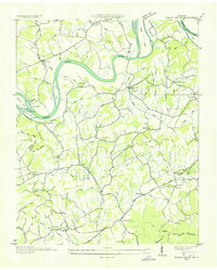
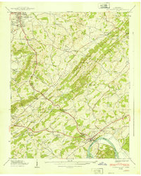
 1935 Dandridge1935 Print · USGSEast Tennessee in the mid-1930s is mapped here in great detail as the region's river valleys prepared for the impacts of the Tennessee Valley Authority. Researchers can trace ancestral locations through dozens of landmarks like Martha Sunderland Cem, Panther Creek Mill, and Roe Ch.
 - 1939 Map of Shady Grove
 1939 Shady Grove1939 Print · USGSThe French Broad River valley in the late 1930s was a landscape of river-bottom farms and small upland communities. Genealogists and historians can trace family locations through numerous rural landmarks like Lee Academy, Island Ford Mill, and Shady Grove Cem.2 unique versions available
 - 1939 Map of Jefferson City
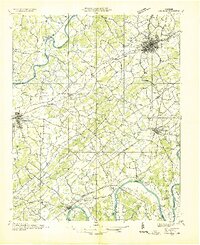
 1939 Jefferson City1939 Print · USGSJefferson County in the late thirties is a landscape of ridge-and-valley farming and early industry along the French Broad River. Genealogists can trace family footprints at Hebron Cem, Hunnicutt Mill, and rural schools like Greenhill Sch.2 unique versions available
End of results
Showing maps 1-6 of 6
Top cities near Dandridge
- Morristown historical maps
- Sevierville historical maps
- Jefferson City historical maps
- Newport historical maps
- Pigeon Forge historical maps
- White Pine historical maps
See more
Top neighborhoods of Dandridge
- Hunnicutt Mill historical maps
- Grants Chapel historical maps
- Oakland historical maps
- Jefferson County Industrial Park historical maps
- Lake View Park historical maps
- Sugar Forks historical maps
Frequently asked questions
- What are the different types of historical maps available for Dandridge?
- What is the oldest map of Dandridge?
- Where can I purchase historical maps of Dandridge for my home or office?
- Where can I download high-res historical maps of Dandridge?
- Are there historical topographic maps available for Dandridge?
- Is there historical aerial imagery available for Dandridge?
- Where are historical maps of Dandridge sourced from?