1960s Maps of Dandridge, Tennessee
Explore 6 historic maps of Dandridge from the 1960s. These maps offer a rare glimpse into what life looked like during the 1960s — showing old roads, neighborhoods, homes, and landmarks that have changed or disappeared over time.
Whether you're researching your family's past, planning a metal detecting trip, or studying how Dandridge's landscape evolved across the 1960s, these high-resolution maps are a powerful tool for exploring the history of this region.
- Focus on a specific era: All maps on this page are from the 1960s, giving you a focused view of this time period.
- See what’s changed: Compare century-old streets, trails, and buildings to today's modern landscape using overlays and satellite layers.
- Research with precision: Use these maps for genealogy, historical research, land use analysis, or educational projects.
- View, download, or print: Maps are fully viewable online in high resolution, and can be downloaded or printed for your own records.
Start exploring Dandridge's history through authentic maps from the 1960s. This is your window into the past.
Dandridge, TN maps
(6)- 1960 Map of Knoxville
 1960 Knoxville1960 Print · USGSThe Southern Appalachians come alive in the 1950s, showing the intersection of new national park tourism and deep-rooted mountain industry. Trace old rail lines like the Clinchfield RR and find high-altitude landmarks from Mt Le Conte to the Cherokee Indian Reservation.2 unique versions available
 - 1960 Map of Johnson City
 1960 Johnson City1960 Print · USGSUpper East Tennessee and the surrounding tri-state area are shown in the mid-fifties during the height of the TVA reservoir era. Trace the industrial rail lines of the Southern and Louisville and Nashville between Kingsport and Johnson City.
 - 1961 Map of Shady Grove, 1963 Print
 1961 Shady Grove1963 Print · USGSDouglas Lake and its winding shoreline define this 1960s landscape along the border of Jefferson and Sevier Counties. Genealogists and local historians can trace legacy landmarks like Derrick Cemetery, Hills Union Ch, and New Center School.2 unique versions available
 - 1961 Map of Jefferson City, 1963 Print
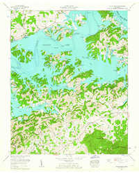
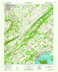 1961 Jefferson City1963 Print · USGSJefferson and Dandridge are captured here in the early sixties as industrial mining and the rising waters of Douglas Lake reshape the valley. Genealogists can trace family names at Hebron Cem and Wesley Chapel, or locate the Hunnicutt Mill and Coy Mine.3 unique versions available
 - 1963 Map of Johnson City
 1963 Johnson City1963 Print · USGSThe Tri-Cities and the surrounding Appalachian ridges are shown in detail during the early sixties, highlighting the era's vital rail and river networks. Genealogists and historians can trace the routes of the Clinchfield RR and locate settlements from Rogersville to Elizabethton.
 - 1964 Map of Knoxville
 1964 Knoxville1964 Print · USGSThe Southern Appalachians and Great Smokies are captured here during the mid-sixties, showing the rugged borderlands of Tennessee and North Carolina. Researchers can trace historic mountain routes like U S 441, the expanse of Pisgah National Forest, and the growing footprints of Asheville and Knoxville.
End of results
Showing maps 1-6 of 6
Top cities near Dandridge
- Morristown historical maps
- Sevierville historical maps
- Jefferson City historical maps
- Newport historical maps
- Pigeon Forge historical maps
- White Pine historical maps
See more
Top neighborhoods of Dandridge
- Hunnicutt Mill historical maps
- Grants Chapel historical maps
- Oakland historical maps
- Jefferson County Industrial Park historical maps
- Lake View Park historical maps
- Sugar Forks historical maps
Frequently asked questions
- What are the different types of historical maps available for Dandridge?
- What is the oldest map of Dandridge?
- Where can I purchase historical maps of Dandridge for my home or office?
- Where can I download high-res historical maps of Dandridge?
- Are there historical topographic maps available for Dandridge?
- Is there historical aerial imagery available for Dandridge?
- Where are historical maps of Dandridge sourced from?