1930s Maps of Dumplin Mill, Tennessee
Explore 2 historic maps of Dumplin Mill from the 1930s. These maps offer a rare glimpse into what life looked like during the 1930s — showing old roads, neighborhoods, homes, and landmarks that have changed or disappeared over time.
Whether you're researching your family's past, planning a metal detecting trip, or studying how Dumplin Mill's landscape evolved across the 1930s, these high-resolution maps are a powerful tool for exploring the history of this region.
- Focus on a specific era: All maps on this page are from the 1930s, giving you a focused view of this time period.
- See what’s changed: Compare century-old streets, trails, and buildings to today's modern landscape using overlays and satellite layers.
- Research with precision: Use these maps for genealogy, historical research, land use analysis, or educational projects.
- View, download, or print: Maps are fully viewable online in high resolution, and can be downloaded or printed for your own records.
Start exploring Dumplin Mill's history through authentic maps from the 1930s. This is your window into the past.
Dumplin Mill, TN maps
(2)- 1935 Map of Sevierville
 1935 Sevierville1935 Print · USGSSevier County during the mid-1930s is captured here in transition, showing the river-dependent communities along the French Broad River before modern development. Genealogists and historians can trace early school sites like Seven Islands Sch and old river crossings such as Trundle Ferry.
 - 1935 Map of Kykers Ferry
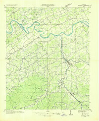
 1935 Kykers Ferry1935 Print · USGSThe French Broad and Little Pigeon rivers meet in this mid-1930s survey of the Sevier and Jefferson county line. Genealogists and historians can trace the locations of Kykers Ferry, the French Broad Academy, and family-named cemeteries like Underwood Cem.
End of results
Showing maps 1-2 of 2
Top cities near Dumplin Mill
- Knoxville historical maps
- Morristown historical maps
- Sevierville historical maps
- Jefferson City historical maps
- Pigeon Forge historical maps
- Mascot historical maps
See more
Frequently asked questions
- What are the different types of historical maps available for Dumplin Mill?
- What is the oldest map of Dumplin Mill?
- Where can I purchase historical maps of Dumplin Mill for my home or office?
- Where can I download high-res historical maps of Dumplin Mill?
- Are there historical topographic maps available for Dumplin Mill?
- Is there historical aerial imagery available for Dumplin Mill?
- Where are historical maps of Dumplin Mill sourced from?