1935 Map of Sevierville
USGS Topo · Published 1935About this map
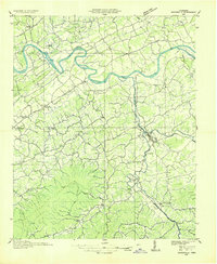
Sevierville serves as the focal point of this 1935 Tennessee Valley Authority and USGS collaboration, situated at the confluence of the Little Pigeon River and its West Fork. The landscape is defined by the transition from the winding French Broad River in the north to the prominent ridges of Chilhowee Mountain and Bays Mountain in the south. The river system remains a primary corridor for travel and commerce, evidenced by active crossings like Trundle Ferry and Huffman Ferry before the widespread construction of modern bridges.
Find a feature on this map
81 named features on this map. Tap any name to fly to it.
Don’t see what you’re looking for? This feature index may not catch every label — zoom into the map to look around manually.
Map Details
Editions of this 1935 Sevierville Map
This is the sole edition of this map. No revisions or reprints were ever made.
Historical Maps of Knoxville Through Time
1 maps found