1970s Maps of Lake County, Tennessee
Explore 8 historic maps of Lake County from the 1970s. These maps offer a rare glimpse into what life looked like during the 1970s — showing old roads, neighborhoods, homes, and landmarks that have changed or disappeared over time.
Whether you're researching your family's past, planning a metal detecting trip, or studying how Lake County's landscape evolved across the 1970s, these high-resolution maps are a powerful tool for exploring the history of this region.
- Focus on a specific era: All maps on this page are from the 1970s, giving you a focused view of this time period.
- See what’s changed: Compare century-old streets, trails, and buildings to today's modern landscape using overlays and satellite layers.
- Research with precision: Use these maps for genealogy, historical research, land use analysis, or educational projects.
- View, download, or print: Maps are fully viewable online in high resolution, and can be downloaded or printed for your own records.
Start exploring Lake County's history through authentic maps from the 1970s. This is your window into the past.
Lake County, TN maps
(8)- 1971 Map of Tennemo, 1972 Print
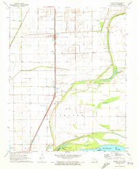
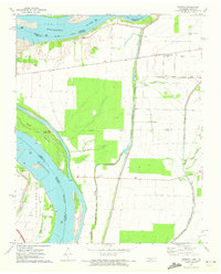 1971 Tennemo1972 Print · USGSThe Mississippi River bottoms of Lake County come into focus during the early 1970s, showing a landscape defined by levees and drainage bayous. Researchers can trace the layout of riverside hamlets like Tennemo and Owl Hoot, or locate the Cottonwood Ch near the Tennessee-Missouri border.2 unique versions available
 - 1971 Map of Caruthersville, 1973 Print
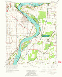
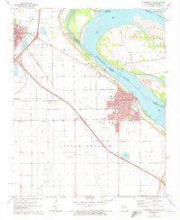 1971 Caruthersville1973 Print · USGSThe Mississippi River levee system and early interstate expansion define this riverfront area in the early seventies. Trace local genealogy and industry through Magnolia Cem, the Indian Mound, and the busy St Louis Southwestern rail lines.3 unique versions available
 - 1971 Map of Point Pleasant, 1973 Print
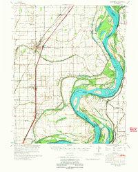
 1971 Point Pleasant1973 Print · USGSThe Missouri-Tennessee borderlands in the early 1970s reveal a landscape of river-town life and family burial grounds along the Mississippi River. Researchers can trace local roots at Le Sieur Cem, Lily of the Valley Ch, and the ferry crossing at Linda.2 unique versions available
 - 1971 Map of Mooring, 1973 Print
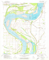 1971 Mooring1973 Print · USGSThe Mississippi River forms a complex boundary between Missouri and Tennessee in the early 1970s, carving a landscape of shifting towheads and chutes. Researchers can find historical river access points and family sites such as Burrus Landing, Mooring Cem, and Island No 13.2 unique versions available
 - 1971 Map of Stanley, 1973 Print
 1971 Stanley1973 Print · USGSIn the early 1970s, this Mississippi River borderland shows a landscape of productive farm townships and riverside bayous. Researchers can locate family landmarks like Stancil Cem, Averill Cem, and the settlement of Concord.2 unique versions available
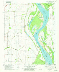
 - 1972 Map of Bayouville
 1972 Bayouville1972 Print · USGSThe tri-state river country of Missouri, Kentucky, and Tennessee is mapped here in the early seventies as a land of massive river bends and ancient mounds. Researchers can trace historic earthworks at Corner Stone Indian Mound, find rural burials at Cole Cem, and locate settlements like Dorena and Farrenburg.
 - 1973 Map of Caruthersville
 1973 Caruthersville1973 Print · USGSThe Missouri Bootheel meets the Tennessee state line in the early 1970s, where the Mississippi River winds past Caruthersville. Local historians can trace family roots through numerous sites like Little Prairie Cem, Marvin Chapel, and the community at Hayti.
 - 1973 Map of Portageville
 1973 Portageville1973 Print · USGSThe Missouri Bootheel near Portageville was a landscape of intensive drainage and river commerce in the early seventies. Genealogists and local historians can trace family burial sites like Kimes Cem and rural landmarks such as North Pemiscot Sch.
End of results
Showing maps 1-8 of 8
Top cities of Lake County
Frequently asked questions
- What are the different types of historical maps available for Lake County?
- What is the oldest map of Lake County?
- Where can I purchase historical maps of Lake County for my home or office?
- Where can I download high-res historical maps of Lake County?
- Are there historical topographic maps available for Lake County?
- Is there historical aerial imagery available for Lake County?
- Where are historical maps of Lake County sourced from?