1960s Maps of Lake County, Tennessee
Explore 7 historic maps of Lake County from the 1960s. These maps offer a rare glimpse into what life looked like during the 1960s — showing old roads, neighborhoods, homes, and landmarks that have changed or disappeared over time.
Whether you're researching your family's past, planning a metal detecting trip, or studying how Lake County's landscape evolved across the 1960s, these high-resolution maps are a powerful tool for exploring the history of this region.
- Focus on a specific era: All maps on this page are from the 1960s, giving you a focused view of this time period.
- See what’s changed: Compare century-old streets, trails, and buildings to today's modern landscape using overlays and satellite layers.
- Research with precision: Use these maps for genealogy, historical research, land use analysis, or educational projects.
- View, download, or print: Maps are fully viewable online in high resolution, and can be downloaded or printed for your own records.
Start exploring Lake County's history through authentic maps from the 1960s. This is your window into the past.
Lake County, TN maps
(7)- 1961 Map of Dyersburg, 1965 Print
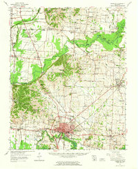 1961 Dyersburg1965 Print · USGSDyer County at the start of the sixties reveals a thriving rail-and-river hub centered on the growing city of Dyersburg. Researchers can trace family roots through numerous rural landmarks like Bruces Chapel, Cloverdale Sch, and the Newbern Cem.
 - 1964 Map of Tiptonville, 1965 Print
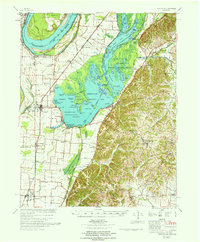
 1964 Tiptonville1965 Print · USGSTiptonville and the Mississippi River bottoms are captured in the mid-sixties, showing a landscape defined by shifting river channels and the waters of Reelfoot Lake. Genealogists can locate family sites like Cronanville Cem, Mt Zion Ch, and the Indian Mound.2 unique versions available
 - 1964 Map of Samburg, 1965 Print
 1964 Samburg1965 Print · USGSReelfoot Lake and the surrounding bottomlands are captured here in the mid-1960s as both a refuge and a living community. Genealogists and local historians can trace the roads connecting Samburg, Walnut Log, and Roneys Store, or locate family sites near Midway Ch and Mt Zion Ch.2 unique versions available
 - 1964 Map of Ridgely, 1965 Print
 1964 Ridgely1965 Print · USGSMid-century Lake County comes to life as a network of wetland refuges and agricultural rail towns before modern landscape changes. Genealogists can locate family sites at New Haven Cem and Crocketts Chapel, or trace the tracks of the Illinois Central through Ridgely and Wynnburg.2 unique versions available
 - 1967 Map of Reelfoot Lake
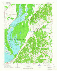
 1967 Reelfoot Lake1967 Print · USGSReelfoot Lake and the Mississippi riverfront are captured here in the mid-sixties, showing a landscape defined by wetlands and rail-line towns. Researchers can trace family sites at Owl City or Samburg, and locate landmarks like Mt Zion Ch and Oak Ridge Sch.
 - 1969 Map of Hubbard Lake, 1972 Print
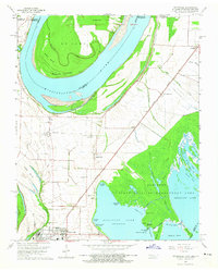
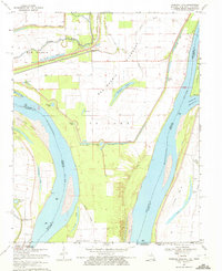 1969 Hubbard Lake1972 Print · USGSThe Mississippi River bends through the tri-state borderlands of Missouri, Kentucky, and Tennessee during the late 1960s. Researchers can trace the legacy of river settlements and flood control through features like the Madrid Bend Ch, Adams Cem, and the massive New Madrid Levee.2 unique versions available
 - 1969 Map of Bondurant, 1972 Print
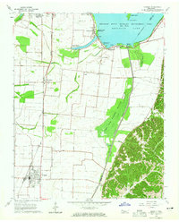
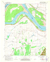 1969 Bondurant1972 Print · USGSThe tri-state border region of Kentucky, Missouri, and Tennessee comes alive in this late-sixties study of the Mississippi river bends. Genealogists can locate family landmarks like Sassafras Ridge Ch, Western Sch, and the Indian Mound.2 unique versions available
End of results
Showing maps 1-7 of 7
Top cities of Lake County
Frequently asked questions
- What are the different types of historical maps available for Lake County?
- What is the oldest map of Lake County?
- Where can I purchase historical maps of Lake County for my home or office?
- Where can I download high-res historical maps of Lake County?
- Are there historical topographic maps available for Lake County?
- Is there historical aerial imagery available for Lake County?
- Where are historical maps of Lake County sourced from?