1930s Maps of Lewis County, Tennessee
Explore 11 historic maps of Lewis County from the 1930s. These maps offer a rare glimpse into what life looked like during the 1930s — showing old roads, neighborhoods, homes, and landmarks that have changed or disappeared over time.
Whether you're researching your family's past, planning a metal detecting trip, or studying how Lewis County's landscape evolved across the 1930s, these high-resolution maps are a powerful tool for exploring the history of this region.
- Focus on a specific era: All maps on this page are from the 1930s, giving you a focused view of this time period.
- See what’s changed: Compare century-old streets, trails, and buildings to today's modern landscape using overlays and satellite layers.
- Research with precision: Use these maps for genealogy, historical research, land use analysis, or educational projects.
- View, download, or print: Maps are fully viewable online in high resolution, and can be downloaded or printed for your own records.
Start exploring Lewis County's history through authentic maps from the 1930s. This is your window into the past.
Lewis County, TN maps
(11)- 1936 Map of Riverside
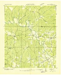
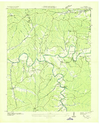
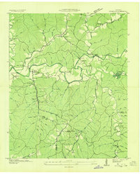 1936 Riverside1936 Print · USGSThe Buffalo River valley in the mid-1930s shows a landscape of small settlements and river crossings like Metal Ford. Trace family history at CCC Camp No 1472 or local landmarks like Ruppertown and Riverside Sch.
 - 1936 Map of Graves Spring
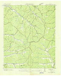 1936 Graves Spring1936 Print · USGSMid-depression Tennessee highlands are captured here at the intersection of Perry, Lewis, and Hickman Counties. Researchers can locate remote family burial sites like Poplin Hollow Cem and early educational landmarks including Upper Coon Creek Sch.
 - 1936 Map of Mt Joy
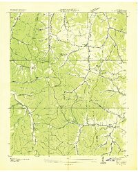 1936 Mt Joy1936 Print · USGSThe rural borderlands of Lewis and Maury counties are captured here in the mid-1930s as a landscape of small crossroads and family farms. Researchers can trace ancestral roots through numerous local landmarks like Willis Chapel, Dixon Spring Cem, and Macedonia Sch.
 - 1936 Map of Beaverdam Springs
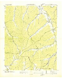 1936 Beaverdam Springs1936 Print · USGSHickman and Lewis Counties were characterized by small crossroads settlements and ridge-line roads in the mid-1930s. Genealogists can trace family footprints through sites like Wade Cem, Byers Chapel, and the vanished Beaverdam Springs Sch.
 - 1936 Map of Henryville
 1936 Henryville1936 Print · USGSThe Tennessee hills between Lewis and Lawrence counties come into focus in the mid-1930s, showing a landscape defined by the winding Buffalo River. Researchers can trace old family roots at Henryville Cem or locate community centers like Garrotts Sch and Napier.
 - 1936 Map of Sunrise
 1936 Sunrise1936 Print · USGSThe rural landscape of Hickman County is captured here in the mid-1930s, showing a transition toward electrification and modern transit. Researchers can locate early schools and churches like Brushy Sch and Raleigh Chapel or trace the Nashville Chattanooga and St Louis Ry through Deans.
 - 1936 Map of Crestview
 1936 Crestview1936 Print · USGSThe Lawrence County highlands in the mid-1930s reveal a landscape shaped by the Louisville and Nashville Railroad and early rural electrification. Local historians can trace family roots through landmarks like Porter Chapel Sch, Pleasant Garden Ch, and the settlement of Rockdale.
 - 1936 Map of Greenfield Bend
 1936 Greenfield Bend1936 Print · USGSThe Duck River valley comes to life in the mid-1930s, showing a network of rural schoolhouses and family cemeteries along the Hickman and Maury county lines. Researchers can trace the local landscape through landmarks like Kettle Mills, the Gordon Ferry Bridge, and Sheboss Cem.
 - 1936 Map of Kimmins
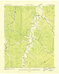
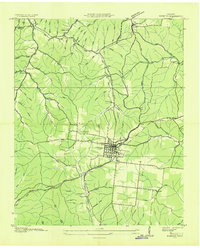 1936 Kimmins1936 Print · USGSLewis County life in the mid-1930s revolves around the rail town of Hohenwald. Genealogists can trace family landmarks like Skelton Sch and the Swiss Cem, while historians can follow the Nashville Chattanooga and St Louis railway.
 - 1936 Map of Topsy
 1936 Topsy1936 Print · USGSWayne County was a network of river crossings and hollow-side farms in the mid-1930s before modern infrastructure altered the landscape. Researchers can trace ancestral roots at Topsy, locate rural hubs like Ashland, and find remote burial sites such as Zion Cem.
 - 1936 Map of Gordonsburg
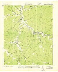 1936 Gordonsburg1936 Print · USGSGordonsburg and the surrounding Lewis County hollows are captured here during the peak of local phosphate extraction in the mid-1930s. Researchers can trace family sites near Mt Sinai Ch or locate industrial landmarks like the Phosphate Mines and the Louisville and Nashville RR.
End of results
Showing maps 1-11 of 11
Top cities of Lewis County
Frequently asked questions
- What are the different types of historical maps available for Lewis County?
- What is the oldest map of Lewis County?
- Where can I purchase historical maps of Lewis County for my home or office?
- Where can I download high-res historical maps of Lewis County?
- Are there historical topographic maps available for Lewis County?
- Is there historical aerial imagery available for Lewis County?
- Where are historical maps of Lewis County sourced from?