Old Maps of Lincoln County, Tennessee
Explore 163 old maps of Lincoln County, spanning from 1888 to today. These high-resolution historic maps reveal how streets, neighborhoods, landmarks, and natural features evolved over time — perfect for genealogy, metal detecting, research, and local history exploration.
What you can do with these maps:
- See how Lincoln County changed over time: Compare historical maps to modern-day views to trace roads, homesites, rail lines & more.
- View detailed metadata: Each map includes creators, publishers, year, scale, and archive source.
- Overlay maps with satellite & LiDAR: Visualize the past alongside modern tools to explore terrain & human change.
- Trusted historical sources: Maps sourced from the USGS, Library of Congress, and other archives.
- Access maps your way: View online, download high-res files, or order prints for personal or research use.
Start exploring old maps of Lincoln County to uncover forgotten places, hidden landmarks, and the deep history beneath your feet.
Lincoln County, TN maps
(163)- 1888 Map of Scottsboro
 1888 Scottsboro1888 Print · USGSNortheast Alabama is shown in the late nineteenth century as a land of steep plateaus and vital river crossings. Genealogists and researchers can trace the early rail-and-river economy through family landmarks like Caldwell's Ferry and the Bell Factory textile site.
 - 1888 Map of Huntsville
 1888 Huntsville1888 Print · USGSMadison and Limestone counties in the late 1880s showcase a landscape defined by the Tennessee River and major early rail lines. Researchers can trace the layout of Huntsville or locate long-standing communities like Mooresville and Thompsons Mill.
 - 1892 Map of Huntsville
 1892 Huntsville1892 Print · USGSNorth Alabama was a landscape of river ferries and rising rail hubs in the 1890s, caught here just as the region's industry began to modernize. Researchers can locate vanished landmarks like the Monte Sano Hotel and trace old family-named sites from Thompsons Mill to Lemans Ferry.6 unique versions available
 - 1892 Map of Scottsboro
 1892 Scottsboro1892 Print · USGSJackson County and the Tennessee River valley are captured here in the late nineteenth century, just as railroads began to reshape local commerce. Genealogists can trace family-named sites like Owen's Cross Roads, Carrick Mill, and Larkin Landing.5 unique versions available
 - 1936 Map of King Cove
 1936 King Cove1936 Print · USGSThe Alabama-Tennessee borderlands appear here in the mid-1930s, showing a landscape of high ridges and isolated mountain coves. Researchers can locate family landmarks like Crowell Cem and Maxwell Cem or rural centers like Howard Hill Sch.
 - 1936 Map of Booneville
 1936 Booneville1936 Print · USGSThe rural borderlands of Moore, Lincoln, and Bedford counties are captured here in the mid-1930s during a period of steady local development. Researchers can pinpoint early community hubs like Screamersville, Charity Sch, and the river crossing at Booneville.
 - 1936 Map of Flintville
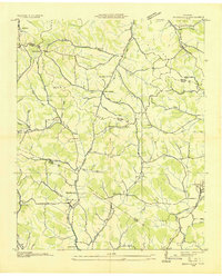
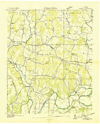
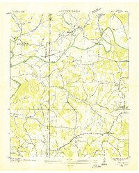
 1936 Flintville1936 Print · USGSLincoln County comes alive in the mid-1930s as a landscape of rail-connected hamlets and early TVA electrification efforts. Genealogists can trace family landmarks like Campbell Cem, Brown Chapel, and the rural McCracken Sch along the Flint River.
 - 1936 Map of Cornersville
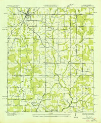
 1936 Cornersville1936 Print · USGSMarshall County's rural landscape is captured here in the mid-1930s as modern power lines and highways began to intersect with long-established farming communities. Genealogists and local historians can trace the locations of the Gnat Grove Sch, Richland Ch, and small settlements like Graball and Diana.
 - 1936 Map of Taft
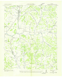
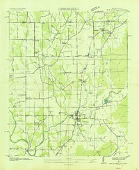
 1936 Taft1936 Print · USGSLincoln County at the height of the mid-thirties rural electrification era is captured here in fine detail. Genealogists and local historians can trace family locations near Taft, Coldwater, and Molino, or find markers like Bryant Cem and Smith Chapel.
 - 1936 Map of Belleville
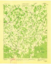
 1936 Belleville1936 Print · USGSLincoln County and the surrounding borderlands are captured here in the mid-1930s, showing a rural landscape organized around deep hollows and creek branches. Researchers can locate numerous local landmarks including Oak Hill Ch, Patton Cem, and the settlement of Belleville.
 - 1936 Map of Fisk
 1936 Fisk1936 Print · USGSThe Alabama-Tennessee borderlands north of Huntsville appear here during the mid-thirties, showing a rural landscape of dispersed farmsteads and small crossroads. Genealogists can trace family roots through sites like Driskill Cem, St Rebecca Ch, and Farmers Capital Sch.
 - 1936 Map of Boonshill
 1936 Boonshill1936 Print · USGSLincoln County at the height of the 1930s reveals a landscape of tight-knit farming communities and early industrial sites along the river. Genealogists can trace family roots through numerous sites like Sulphur Springs Cem, Boonshill Sch, and Antioch Ch.2 unique versions available
 - 1936 Map of Ardmore
 1936 Ardmore1936 Print · USGSThe Alabama-Tennessee borderlands appear here in the mid-1930s, showing the early growth of ARDMORE along the LOUISVILLE AND NASHVILLE railroad. Genealogists can trace family landmarks like Hatchett Cem and rural school sites such as Wooley Springs Sch.
 - 1936 Map of Petersburg
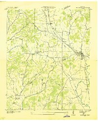 1936 Petersburg1936 Print · USGSThe Marshall and Lincoln county line area appears here in the mid-1930s, centered on the railroad hub of Petersburg. Researchers can trace rural life through numerous country institutions like Haislip Sch, Catalpa Grove Ch, and the Talley Cem.
 - 1936 Map of Lincoln
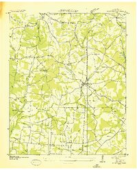
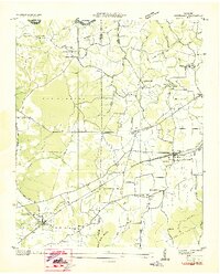
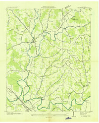
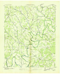
 1936 Lincoln1936 Print · USGSLincoln County in the mid-1930s shows a landscape of river-bend settlements and emerging TVA utility lines. Genealogists can trace family locations near Skinem Cem, Rozells Mill, and rural schoolhouses like Quick Sch or Johnson Sch.
 - 1936 Map of Huntland
 1936 Huntland1936 Print · USGSFranklin County's rail-and-mill economy is on full display in the mid-thirties as the Nashville Chattanooga and St Louis Ry connects Huntland and Elora. Researchers can trace the heritage of rural communities through sites like Stonewall Mill, Simmons Chapel, and the Mc Clure Cem.
 - 1936 Map of Toney
 1936 Toney1936 Print · USGSThe Tennessee-Alabama borderlands come into focus in the mid-1930s, showing a rural landscape defined by the Brier Fork Flint River. Genealogists can trace family names at Golightly Cem and Ready Cem or locate community hubs like New Sharon and Leas Store.
 - 1936 Map of New Market
 1936 New Market1936 Print · USGSMadison County, Alabama, is documented here in the mid-1930s as a landscape defined by the Old Cherokee Boundary and the railroad. Researchers can trace ancestral roots at New Market or locate family sites like Taylor Cem and Hickory Grove Ch.
 - 1936 Map of Mulberry
 1936 Mulberry1936 Print · USGSMiddle Tennessee's river valleys come alive in the mid-1930s, showing the early reach of the TVA and the local rail network. Trace the paths to Lockes Mill, Lloyd Chapel, and family sites like Cowley Cem or Smith Cem.
 - 1936 Map of Frankewing
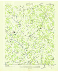 1936 Frankewing1936 Print · USGSThe Giles and Lincoln County border in the mid-1930s was a landscape of creek-side hamlets and rail-line commerce. Genealogists can trace family landmarks like Youngs Chapel Cem, Sawyer Cem, and the community at Bee Spring Hill.
 - 1936 Map of Fayetteville
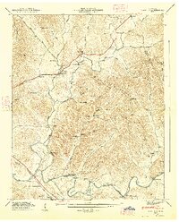
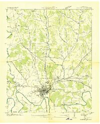 1936 Fayetteville1936 Print · USGSMid-1930s Fayetteville is captured here during the era of TVA expansion and Depression-era public works. Genealogists and researchers can trace local family roots through numerous landmarks like Harris Cem, the Mimosa Sch, and CCC Camp TVA No 33.
 - 1936 Map of Dellrose
 1936 Dellrose1936 Print · USGSSouthern Tennessee at the height of the mid-1930s reveals a rural landscape shaped by the ELK RIVER and the LOUISVILLE AND NASHVILLE railroad. Genealogists can locate family landmarks like STONE CEM or Hamiltons Mill and trace the rail line through the unique LUDA TUNNEL.
 - 1936 Map of Lois
 1936 Lois1936 Print · USGSMoore County at the start of the Tennessee Valley Authority era shows a landscape of river-bend farms and scattered crossroads settlements. Genealogists can locate family-named landmarks such as Gray Cem, Browningtown, and the Liberty Hill Sch along the Elk River.
 - 1944 Map of Shelbyville
 1944 Shelbyville1944 Print · USGSMid-century Middle Tennessee is captured here during the wartime mobilization of the 1940s. Genealogists and researchers can trace family lands near Bugscuffle, Shelbyville Mills, and the expansive Camp Forrest Military Res.
 - 1947 Map of Mulberry, 1948 Print
 1947 Mulberry1948 Print · USGSLincoln County and Moore County communities thrive along the Elk River and its tributaries during the late 1940s. Genealogists and historians can trace family homesteads through over a dozen named burial sites like Renegar Cem, find landmarks like Lockes Mill, and locate the Moore Chapel Sch.3 unique versions available
Showing maps 1-25 of 163
Top cities of Lincoln County
Frequently asked questions
- What are the different types of historical maps available for Lincoln County?
- What is the oldest map of Lincoln County?
- Where can I purchase historical maps of Lincoln County for my home or office?
- Where can I download high-res historical maps of Lincoln County?
- Are there historical topographic maps available for Lincoln County?
- Is there historical aerial imagery available for Lincoln County?
- Where are historical maps of Lincoln County sourced from?