1940s Maps of Lincoln County, Tennessee
Explore 16 historic maps of Lincoln County from the 1940s. These maps offer a rare glimpse into what life looked like during the 1940s — showing old roads, neighborhoods, homes, and landmarks that have changed or disappeared over time.
Whether you're researching your family's past, planning a metal detecting trip, or studying how Lincoln County's landscape evolved across the 1940s, these high-resolution maps are a powerful tool for exploring the history of this region.
- Focus on a specific era: All maps on this page are from the 1940s, giving you a focused view of this time period.
- See what’s changed: Compare century-old streets, trails, and buildings to today's modern landscape using overlays and satellite layers.
- Research with precision: Use these maps for genealogy, historical research, land use analysis, or educational projects.
- View, download, or print: Maps are fully viewable online in high resolution, and can be downloaded or printed for your own records.
Start exploring Lincoln County's history through authentic maps from the 1940s. This is your window into the past.
Lincoln County, TN maps
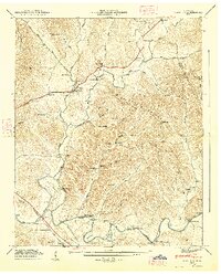
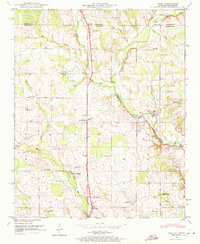
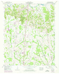
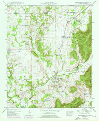
(16)- 1944 Map of Shelbyville
 1944 Shelbyville1944 Print · USGSMid-century Middle Tennessee is captured here during the wartime mobilization of the 1940s. Genealogists and researchers can trace family lands near Bugscuffle, Shelbyville Mills, and the expansive Camp Forrest Military Res.
 - 1947 Map of Mulberry, 1948 Print
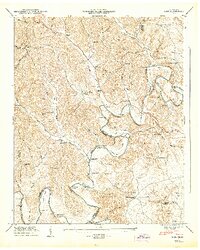
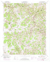
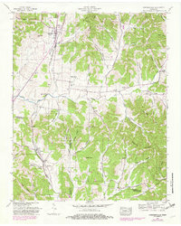
 1947 Mulberry1948 Print · USGSLincoln County and Moore County communities thrive along the Elk River and its tributaries during the late 1940s. Genealogists and historians can trace family homesteads through over a dozen named burial sites like Renegar Cem, find landmarks like Lockes Mill, and locate the Moore Chapel Sch.3 unique versions available
 - 1947 Map of Lois, 1948 Print
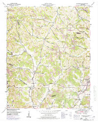
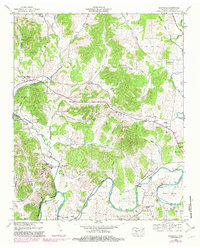
 1947 Lois1948 Print · USGSMoore and Franklin counties are shown here just after the war, where the ELK RIVER winds through a landscape of family-named ridges and hollows. Researchers can trace old homesteads and community anchors like Lois, Brandon Chapel, and the Sylvania Sch.2 unique versions available
 - 1947 Map of Huntland, 1948 Print
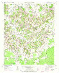
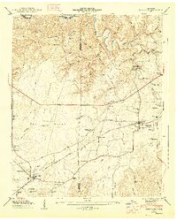 1947 Huntland1948 Print · USGSFranklin and Lincoln County life in the late 1940s centers on the rail corridor and river bends south of the Elk River. Local historians can trace family roots through sites like Falls Mill, Simmons Chapel, and numerous family burial grounds including Mc Clure Cem.4 unique versions available
 - 1947 Map of Flintville, 1948 Print
 1947 Flintville1948 Print · USGSMid-century Lincoln County comes to life as an active rail and river hub just after the war. Local historians can trace family ties at Stewart Chapel, the State Fish Hatchery, or small settlements like Brighton and Milners Switch.3 unique versions available
 - 1948 Map of King Cove, 1967 Print
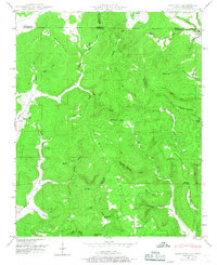 1948 King Cove1967 Print · USGSThe Alabama-Tennessee borderlands appear here in the late 1940s, showing a landscape of isolated coves and mountain ridges. Researchers can locate remote family sites like Hayes Cem and Francisco, or trace the complex karst drainage near Hambrick Sinks.3 unique versions available
 - 1948 Map of Fisk, 1971 Print
 1948 Fisk1971 Print · USGSMadison County, Alabama, and Lincoln County, Tennessee, meet at this mid-century rural crossroads where the Flint River valley supported a landscape of mills and country churches. Researchers can trace family sites like Stegers Store, Farmers Capitol School, and Townsend Cem along the old short route.2 unique versions available
 - 1948 Map of Frankewing, 1975 Print
 1948 Frankewing1975 Print · USGSGiles and Lincoln counties are captured here at mid-century, just as modern road improvements began to reshape the rural landscape. Researchers can trace family history through numerous landmarks like Center Ridge School, Hedgepeth Cem, and the village of Frankewing.2 unique versions available
 - 1948 Map of Dellrose, 1982 Print
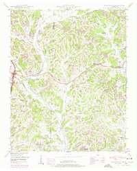
 1948 Dellrose1982 Print · USGSLincoln and Giles counties were defined by the winding Elk River and the Louisville and Nashville railroad in the late 1940s. Genealogists and historians can trace family roots through numerous landmarks like Washington Temple, Hamilton Mill, and Young Cem.
 - 1949 Map of Lincoln, 1973 Print
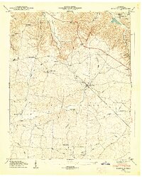
 1949 Lincoln1973 Print · USGSMiddle Tennessee's river valleys and rural crossroads are captured here during the late 1940s. Researchers can locate family landmarks like Rozells Mill, the settlement of Skinem, and several country burial sites including Wells Hill Cem.3 unique versions available
 - 1949 Map of Belleville, 1974 Print
 1949 Belleville1974 Print · USGSLincoln County was a landscape of high ridges and deep hollows in the years following the war, centered around the community of Belleville. Researchers can trace old family burial grounds and country parishes like Hickory Hill Church and Wylie Cemetery.2 unique versions available
 - 1949 Map of Booneville, 1974 Print
 1949 Booneville1974 Print · USGSMoore County and the surrounding ridges come to life in this mid-century survey of the region around the Lynchburg distillery country. Genealogists can trace family footprints across dozens of named hollows and remote burial sites like Shoffner Cem and Cox Cem.2 unique versions available
 - 1949 Map of Taft, 1974 Print
 1949 Taft1974 Print · USGSLincoln County comes to life in this mid-century survey of the rugged ridges and river bottoms north of the Alabama line. Genealogists can trace family roots through numerous sites like Marys Grove School, Smith Chapel, and the Milam Cem.2 unique versions available
 - 1949 Map of New Market, 1976 Print
 1949 New Market1976 Print · USGSMadison County and the Tennessee state line are captured in the mid-century as rural communities like New Market and Plevna thrived along the rail lines. Genealogists can trace family landmarks and historic property lines along the Old Cherokee Boundary and near Bloucher Ford.
 - 1949 Map of Cornersville, 1982 Print
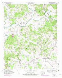
 1949 Cornersville1982 Print · USGSCornersville and the surrounding Tennessee hill country are captured here at the end of the 1940s as the rail and river economy persisted. Researchers can trace the Louisville and Nashville line and find vanished landmarks like the County farm and New Hope Church.
 - 1949 Map of Boonshill, 1982 Print
 1949 Boonshill1982 Print · USGSLincoln County at the midpoint of the century reveals a landscape of winding river bends and small upland settlements. Genealogists can trace family footprints at Cathey Cem, Boonshill, and rural landmarks like Browns Temple Church.
End of results
Showing maps 1-16 of 16
Top cities of Lincoln County
Frequently asked questions
- What are the different types of historical maps available for Lincoln County?
- What is the oldest map of Lincoln County?
- Where can I purchase historical maps of Lincoln County for my home or office?
- Where can I download high-res historical maps of Lincoln County?
- Are there historical topographic maps available for Lincoln County?
- Is there historical aerial imagery available for Lincoln County?
- Where are historical maps of Lincoln County sourced from?