1940s Maps of Elora, Tennessee
Explore 1 historic maps of Elora from the 1940s. These maps offer a rare glimpse into what life looked like during the 1940s — showing old roads, neighborhoods, homes, and landmarks that have changed or disappeared over time.
Whether you're researching your family's past, planning a metal detecting trip, or studying how Elora's landscape evolved across the 1940s, these high-resolution maps are a powerful tool for exploring the history of this region.
- Focus on a specific era: All maps on this page are from the 1940s, giving you a focused view of this time period.
- See what’s changed: Compare century-old streets, trails, and buildings to today's modern landscape using overlays and satellite layers.
- Research with precision: Use these maps for genealogy, historical research, land use analysis, or educational projects.
- View, download, or print: Maps are fully viewable online in high resolution, and can be downloaded or printed for your own records.
Start exploring Elora's history through authentic maps from the 1940s. This is your window into the past.
Elora, TN maps
(1)- 1947 Map of Huntland, 1948 Print
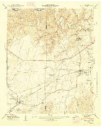 1947 Huntland1948 Print · USGSFranklin and Lincoln County life in the late 1940s centers on the rail corridor and river bends south of the Elk River. Local historians can trace family roots through sites like Falls Mill, Simmons Chapel, and numerous family burial grounds including Mc Clure Cem.4 unique versions available
End of results
Showing maps 1-1 of 1
Top cities near Elora
- Huntsville historical maps
- Meridianville historical maps
- Winchester historical maps
- Fayetteville historical maps
- Moores Mill historical maps
- Hazel Green historical maps
See more
Frequently asked questions
- What are the different types of historical maps available for Elora?
- What is the oldest map of Elora?
- Where can I purchase historical maps of Elora for my home or office?
- Where can I download high-res historical maps of Elora?
- Are there historical topographic maps available for Elora?
- Is there historical aerial imagery available for Elora?
- Where are historical maps of Elora sourced from?