1950s Maps of Fayetteville, Tennessee
Explore 3 historic maps of Fayetteville from the 1950s. These maps offer a rare glimpse into what life looked like during the 1950s — showing old roads, neighborhoods, homes, and landmarks that have changed or disappeared over time.
Whether you're researching your family's past, planning a metal detecting trip, or studying how Fayetteville's landscape evolved across the 1950s, these high-resolution maps are a powerful tool for exploring the history of this region.
- Focus on a specific era: All maps on this page are from the 1950s, giving you a focused view of this time period.
- See what’s changed: Compare century-old streets, trails, and buildings to today's modern landscape using overlays and satellite layers.
- Research with precision: Use these maps for genealogy, historical research, land use analysis, or educational projects.
- View, download, or print: Maps are fully viewable online in high resolution, and can be downloaded or printed for your own records.
Start exploring Fayetteville's history through authentic maps from the 1950s. This is your window into the past.
Fayetteville, TN maps
(3)- 1951 Map of Fayetteville
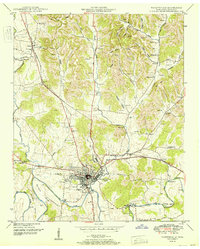 1951 Fayetteville1951 Print · USGSMid-century Fayetteville and the surrounding Lincoln County countryside come alive in this detailed post-war survey. Family historians can trace numerous rural burial grounds and early institutions like Howell Sch, the Mary Chapel, and the Nashville Chattanooga and St Louis rail line.
 - 1951 Map of Lincoln
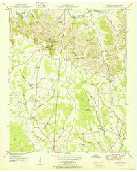 1951 Lincoln1951 Print · USGSThe Tennessee and Alabama borderlands appear here in the early fifties, showing a rural landscape defined by the loops of the Elk River. Local historians can trace the foundations of communities like Lincoln and Boone Falls, or locate family-named sites such as Rozells Mill and Johnson Sch.
 - 1956 Map of Columbia, 1960 Print
 1956 Columbia1960 Print · USGSMiddle Tennessee in the mid-fifties presents a landscape of established river towns and critical rail hubs before the arrival of the modern interstate system. Researchers can trace the routes of the Louisville and Nashville railroad or locate historic landmarks like Stones River National Military Park and the Tennessee National Wildlife Refuge.6 unique versions available
End of results
Showing maps 1-3 of 3
Top cities near Fayetteville
Top neighborhoods of Fayetteville
- Creson historical maps
- Elmwood Terrace historical maps
- Madden Homes historical maps
- Mayberry Courts historical maps
- Elk Mill Village historical maps
Frequently asked questions
- What are the different types of historical maps available for Fayetteville?
- What is the oldest map of Fayetteville?
- Where can I purchase historical maps of Fayetteville for my home or office?
- Where can I download high-res historical maps of Fayetteville?
- Are there historical topographic maps available for Fayetteville?
- Is there historical aerial imagery available for Fayetteville?
- Where are historical maps of Fayetteville sourced from?