1930s Maps of Loudon, Tennessee
Explore 4 historic maps of Loudon from the 1930s. These maps offer a rare glimpse into what life looked like during the 1930s — showing old roads, neighborhoods, homes, and landmarks that have changed or disappeared over time.
Whether you're researching your family's past, planning a metal detecting trip, or studying how Loudon's landscape evolved across the 1930s, these high-resolution maps are a powerful tool for exploring the history of this region.
- Focus on a specific era: All maps on this page are from the 1930s, giving you a focused view of this time period.
- See what’s changed: Compare century-old streets, trails, and buildings to today's modern landscape using overlays and satellite layers.
- Research with precision: Use these maps for genealogy, historical research, land use analysis, or educational projects.
- View, download, or print: Maps are fully viewable online in high resolution, and can be downloaded or printed for your own records.
Start exploring Loudon's history through authentic maps from the 1930s. This is your window into the past.
Loudon, TN maps
(4)- 1935 Map of Lenoir City
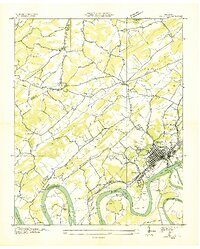 1935 Lenoir City1935 Print · USGSThe Tennessee and Little Tennessee rivers converge here in the mid-1930s, showing a landscape of river bends and ferries. Genealogists can trace family landmarks like Cardwells Chapel, Oral Cem, and the Loudon County Farm.
 - 1935 Map of Philadelphia
 1935 Philadelphia1935 Print · USGSEastern Tennessee valley life comes into focus as the Tennessee Valley Authority begins its work. Genealogists can trace family roots through landmarks like Snows School, Reed Spring Church, and the settlement of Adolphus.
 - 1936 Map of Cave Creek
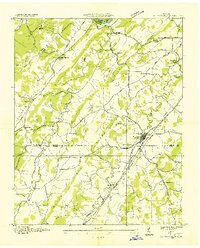
 1936 Cave Creek1936 Print · USGSThe river valleys of Roane and Loudon Counties are captured here in the mid-1930s before decades of modernization. Genealogists can trace family landmarks like Ladd Cem, Norman Cem, and schools such as Matlock School and Beech Grove School.
 - 1936 Map of Loudon
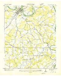 1936 Loudon1936 Print · USGSLoudon County in the mid-1930s is documented here as the Tennessee Valley Authority began its monumental work along the river. Genealogists can locate family-named landmarks and community centers like Eve Mills, Huff Ferry, and Cumberland Stand Ch.
End of results
Showing maps 1-4 of 4
Top cities near Loudon
- Knoxville historical maps
- Oak Ridge historical maps
- Farragut historical maps
- Athens historical maps
- Lenoir City historical maps
- Tellico Village historical maps
See more
Top neighborhoods of Loudon
- Poplar Springs historical maps
- Sugarlimb Industrial Park historical maps
- Blair Bend Industrial Park historical maps
- Highlands Business Park historical maps
Frequently asked questions
- What are the different types of historical maps available for Loudon?
- What is the oldest map of Loudon?
- Where can I purchase historical maps of Loudon for my home or office?
- Where can I download high-res historical maps of Loudon?
- Are there historical topographic maps available for Loudon?
- Is there historical aerial imagery available for Loudon?
- Where are historical maps of Loudon sourced from?