1940s Maps of Loudon, Tennessee
Explore 4 historic maps of Loudon from the 1940s. These maps offer a rare glimpse into what life looked like during the 1940s — showing old roads, neighborhoods, homes, and landmarks that have changed or disappeared over time.
Whether you're researching your family's past, planning a metal detecting trip, or studying how Loudon's landscape evolved across the 1940s, these high-resolution maps are a powerful tool for exploring the history of this region.
- Focus on a specific era: All maps on this page are from the 1940s, giving you a focused view of this time period.
- See what’s changed: Compare century-old streets, trails, and buildings to today's modern landscape using overlays and satellite layers.
- Research with precision: Use these maps for genealogy, historical research, land use analysis, or educational projects.
- View, download, or print: Maps are fully viewable online in high resolution, and can be downloaded or printed for your own records.
Start exploring Loudon's history through authentic maps from the 1940s. This is your window into the past.
Loudon, TN maps
(4)- 1940 Map of Loudon
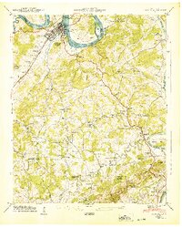 1940 Loudon1940 Print · USGSTennessee river life and rural industry meet in the early 1940s as the river valley begins to transform. Genealogists and historians can trace family landmarks like Eve-Mills, Huff Ferry, and the Maple Spring Wadkins Cem.
 - 1940 Map of Lenoir City
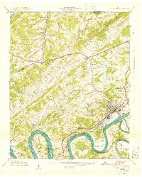 1940 Lenoir City1940 Print · USGSLoudon and Roane counties are captured here just as the Tennessee Valley Authority was reshaping the river landscape. Researchers can trace family-named sites like Brazeale Cem, old schoolhouses such as Oak Grove Sch, and historic river crossings at Bussell Ferry.2 unique versions available
 - 1940 Map of Philadelphia
 1940 Philadelphia1940 Print · USGSThe Tennessee Valley just before the height of the war era shows a landscape of ridge-top schools and creek-side settlements. Researchers can trace ancestral locations at Philadelphia, the Roberson Cem, and rural centers like New Hope Ch.
 - 1940 Map of Cave Creek
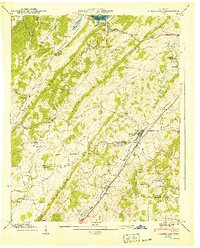
 1940 Cave Creek1940 Print · USGSThe Tennessee River valley stands on the brink of transformation in 1940 as the Watts Bar project prepares to reshape the landscape. Researchers can trace old routes like the Old Walton Road and find family landmarks such as Ladd Cem and Dogwood Sch.
End of results
Showing maps 1-4 of 4
Top cities near Loudon
- Knoxville historical maps
- Oak Ridge historical maps
- Farragut historical maps
- Athens historical maps
- Lenoir City historical maps
- Tellico Village historical maps
See more
Top neighborhoods of Loudon
- Poplar Springs historical maps
- Sugarlimb Industrial Park historical maps
- Blair Bend Industrial Park historical maps
- Highlands Business Park historical maps
Frequently asked questions
- What are the different types of historical maps available for Loudon?
- What is the oldest map of Loudon?
- Where can I purchase historical maps of Loudon for my home or office?
- Where can I download high-res historical maps of Loudon?
- Are there historical topographic maps available for Loudon?
- Is there historical aerial imagery available for Loudon?
- Where are historical maps of Loudon sourced from?