1940s Maps of South Pittsburg, Tennessee
Explore 4 historic maps of South Pittsburg from the 1940s. These maps offer a rare glimpse into what life looked like during the 1940s — showing old roads, neighborhoods, homes, and landmarks that have changed or disappeared over time.
Whether you're researching your family's past, planning a metal detecting trip, or studying how South Pittsburg's landscape evolved across the 1940s, these high-resolution maps are a powerful tool for exploring the history of this region.
- Focus on a specific era: All maps on this page are from the 1940s, giving you a focused view of this time period.
- See what’s changed: Compare century-old streets, trails, and buildings to today's modern landscape using overlays and satellite layers.
- Research with precision: Use these maps for genealogy, historical research, land use analysis, or educational projects.
- View, download, or print: Maps are fully viewable online in high resolution, and can be downloaded or printed for your own records.
Start exploring South Pittsburg's history through authentic maps from the 1940s. This is your window into the past.
South Pittsburg, TN maps
(4)- 1942 Map of South Pittsburg, 1955 Print
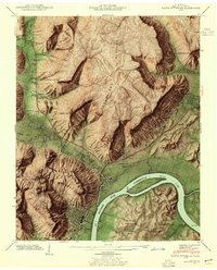 1942 South Pittsburg1955 Print · USGSMarion County's river and mountain landscape comes alive in the 1940s as the Tennessee Valley Authority examines the region's development. Trace family roots at Raulston Cem, visit Jasper, or follow the St Louis and Chattanooga rail line through South Pittsburg.6 unique versions available
 - 1943 Map of South Pittsburg, 1946 Print
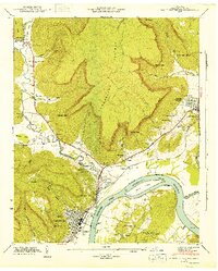 1943 South Pittsburg1946 Print · USGSMarion County enters the mid-century as a vital river and rail corridor where the Cumberland Plateau meets the Tennessee River. Genealogists can trace family names at Raulston Cem, Chaudoin Cem, and rural schools like the Battle Creek Institute.2 unique versions available
 - 1945 Map of Bridgeport
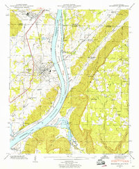 1945 Bridgeport1945 Print · USGSBridgeport and the Tennessee River valley are captured in the mid-1940s as rail and river commerce shaped the Jackson County landscape. Local researchers can trace family sites like Kirkpatrick Cem, the Long Island Sch, and Moore Chapel.3 unique versions available
 - 1946 Map of Bridgeport
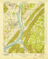 1946 Bridgeport1946 Print · USGSThe Tennessee River valley at Bridgeport is shown here in the mid-1940s, just after the creation of the reservoir. Genealogists can trace family landmarks like Kirkpatrick Cem, Ebenezer Ch, and the crossing at Reese Ferry.2 unique versions available
End of results
Showing maps 1-4 of 4
Top cities near South Pittsburg
- Jasper historical maps
- Sewanee historical maps
- Bridgeport historical maps
- Trenton historical maps
- Stevenson historical maps
- Whitwell historical maps
See more
Top neighborhoods of South Pittsburg
Frequently asked questions
- What are the different types of historical maps available for South Pittsburg?
- What is the oldest map of South Pittsburg?
- Where can I purchase historical maps of South Pittsburg for my home or office?
- Where can I download high-res historical maps of South Pittsburg?
- Are there historical topographic maps available for South Pittsburg?
- Is there historical aerial imagery available for South Pittsburg?
- Where are historical maps of South Pittsburg sourced from?