1950s Maps of Marshall County, Tennessee
Explore 8 historic maps of Marshall County from the 1950s. These maps offer a rare glimpse into what life looked like during the 1950s — showing old roads, neighborhoods, homes, and landmarks that have changed or disappeared over time.
Whether you're researching your family's past, planning a metal detecting trip, or studying how Marshall County's landscape evolved across the 1950s, these high-resolution maps are a powerful tool for exploring the history of this region.
- Focus on a specific era: All maps on this page are from the 1950s, giving you a focused view of this time period.
- See what’s changed: Compare century-old streets, trails, and buildings to today's modern landscape using overlays and satellite layers.
- Research with precision: Use these maps for genealogy, historical research, land use analysis, or educational projects.
- View, download, or print: Maps are fully viewable online in high resolution, and can be downloaded or printed for your own records.
Start exploring Marshall County's history through authentic maps from the 1950s. This is your window into the past.
Marshall County, TN maps
(8)- 1951 Map of Belfast
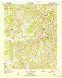
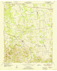 1951 Belfast1951 Print · USGSMarshall County and the Tennessee valley transition toward the mid-century as the Nashville Chattanooga and St Louis Railroad moves freight through Belfast. Researchers can trace family history through local landmarks like Confederate Memorial Park, Union Sch, and the Temple Cem.3 unique versions available
 - 1951 Map of Chapel Hill
 1951 Chapel Hill1951 Print · USGSMid-century Middle Tennessee is captured here as a landscape of family farms and railroad hamlets along the Louisville and Nashville line. Genealogists can trace hundreds of family names through sites like Riggs Crossroads, Edwards Grove Ch, and Marrs Hill Cem.
 - 1951 Map of Campbells Station
 1951 Campbells Station1951 Print · USGSThe hills of Maury and Marshall counties are captured here in the early fifties, showing the rural communities along the Louisville and Nashville railroad. Genealogists can locate numerous family burial grounds and community hubs like Culleoka, Lowery Chapel, and the Mooresville School.3 unique versions available
 - 1951 Map of Cornersville
 1951 Cornersville1951 Print · USGSCornersville and the surrounding Tennessee hills are captured in the early 1950s just as the rail-and-river landscape remained central to rural life. Researchers can locate family landmarks like Beechwood Cemetery, the County Farm, and the Louisville and Nashville rail line.2 unique versions available
 - 1951 Map of Belleville
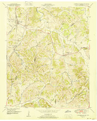
 1951 Belleville1951 Print · USGSMid-century Middle Tennessee is captured here as a landscape of tight-knit valley communities and family ridges. Genealogists can trace the location of numerous burial grounds and rural meeting houses, such as Wylie Cem, Bledsoe Cem, and Oak Hill Ch.2 unique versions available
 - 1951 Map of Lewisburg
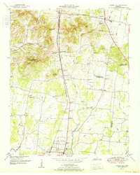
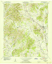
 1951 Lewisburg1951 Print · USGSIn the early fifties, Lewisburg was a critical Tennessee rail junction where the Louisville and Nashville met agricultural industry. Researchers can trace dozens of family cemeteries and local landmarks like Howe Station, Pleasant Hill Church, and the U S Experimental Dairy Farm.
 - 1951 Map of Petersburg
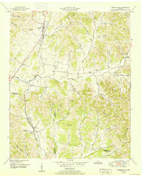
 1951 Petersburg1951 Print · USGSThe Tennessee borderlands of Marshall and Lincoln Counties come to life in the early 1950s, centered on the rail hub of Petersburg. Researchers can trace old family lines through a wealth of rural landmarks like Morgan Sch, Wakefield Chapel, and Toll Gate.3 unique versions available
 - 1956 Map of Columbia, 1960 Print
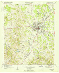
 1956 Columbia1960 Print · USGSMiddle Tennessee in the mid-fifties presents a landscape of established river towns and critical rail hubs before the arrival of the modern interstate system. Researchers can trace the routes of the Louisville and Nashville railroad or locate historic landmarks like Stones River National Military Park and the Tennessee National Wildlife Refuge.6 unique versions available
End of results
Showing maps 1-8 of 8
Top cities of Marshall County
Frequently asked questions
- What are the different types of historical maps available for Marshall County?
- What is the oldest map of Marshall County?
- Where can I purchase historical maps of Marshall County for my home or office?
- Where can I download high-res historical maps of Marshall County?
- Are there historical topographic maps available for Marshall County?
- Is there historical aerial imagery available for Marshall County?
- Where are historical maps of Marshall County sourced from?