Old Maps of Marshall County, Tennessee for Academic Research
Study the evolution of Marshall County with 102 high-resolution historic maps. Whether you're teaching, researching, or modeling changes in land use, these maps provide essential visual documentation of urban, environmental, and geographic change.
- Analyze long-term change: Track patterns in development, transportation, and natural features.
- Ideal for environmental or urban studies: Support academic projects with primary historical map data.
- Use in the classroom or lab: Educators and researchers rely on these maps to bring historical context to life.
These maps are a powerful tool for teaching, research, and visualizing how Marshall County has changed over the decades.
Marshall County, TN maps
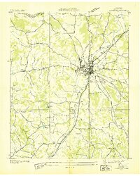
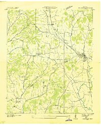
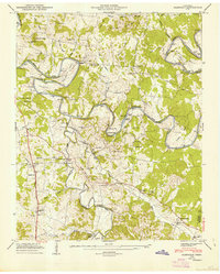
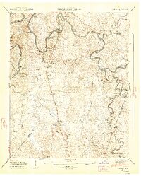
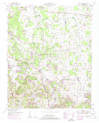
(102)- 1936 Map of Chapel Hill
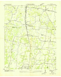 1936 Chapel Hill1936 Print · USGSMiddle Tennessee’s rural landscape is captured here in the mid-1930s as the regional electrical grid was expanding. Researchers can locate vanished landmarks like the Holtland PO, trace family roots at LESTER CEM, or find the old Edwards Grove Ch.
 - 1936 Map of Farmington
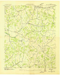
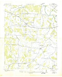
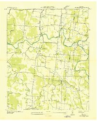 1936 Farmington1936 Print · USGSMarshall County rural life in the mid-1930s is defined by the winding Duck River and a network of family-run farms. Researchers can trace ancestral locations near Wilhoite Mills, Rock Creek Ch, and family burial sites like Thomas Cem.
 - 1936 Map of Belfast
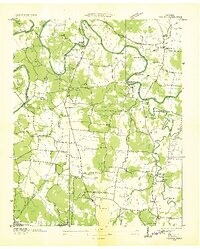
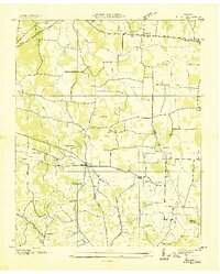 1936 Belfast1936 Print · USGSMarshall County rural life and the local rail economy are captured here just before the late 1930s. Genealogists and historians can trace family locations through Bethel Cem, Cedar Grove Sch, and churches like Head Springs Ch.
 - 1936 Map of Cornersville
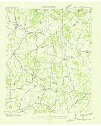
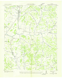 1936 Cornersville1936 Print · USGSMarshall County's rural landscape is captured here in the mid-1930s as modern power lines and highways began to intersect with long-established farming communities. Genealogists and local historians can trace the locations of the Gnat Grove Sch, Richland Ch, and small settlements like Graball and Diana.
 - 1936 Map of Lewisburg
 1936 Lewisburg1936 Print · USGSLewisburg was a thriving rail and agricultural hub in the mid-1930s at the intersection of two major rail lines. Researchers can trace family roots at Lone Oak Cem and Gils Chapel or locate the U S Dept of Agriculture Experimental Dairy Farm.
 - 1936 Map of Belleville
 1936 Belleville1936 Print · USGSLincoln County and the surrounding borderlands are captured here in the mid-1930s, showing a rural landscape organized around deep hollows and creek branches. Researchers can locate numerous local landmarks including Oak Hill Ch, Patton Cem, and the settlement of Belleville.
 - 1936 Map of Brick Church
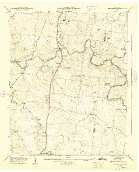
 1936 Brick Church1936 Print · USGSGiles and Marshall Counties come into focus during the mid-1930s, showing a rural landscape organized around creek valleys and small community hubs. Researchers can locate family landmarks like the Odd Fellows Hall or trace school locations such as Woodlawn Sch and Fairview Sch.
 - 1936 Map of Verona
 1936 Verona1936 Print · USGSMarshall County rural life in the thirties followed the winding loops of the Duck River and the tracks of the Louisville and Nashville railroad. Genealogists can locate family landmarks like Bethlehem Cem, Hardison Mill, and the community at Verona.
 - 1936 Map of Campbells Station
 1936 Campbells Station1936 Print · USGSThe rural borderlands of Maury, Marshall, and Giles counties come into focus during the mid-thirties, centered on the Louisville and Nashville rail line. Researchers can trace old family sites and rural centers like Campbells Station, the Ballamfant Cem, and Mooresville Sch.
 - 1936 Map of Petersburg
 1936 Petersburg1936 Print · USGSThe Marshall and Lincoln county line area appears here in the mid-1930s, centered on the railroad hub of Petersburg. Researchers can trace rural life through numerous country institutions like Haislip Sch, Catalpa Grove Ch, and the Talley Cem.
 - 1936 Map of Rally Hill
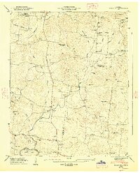
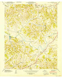
 1936 Rally Hill1936 Print · USGSThe rural borders of Maury, Williamson, and Marshall counties are shown here during the mid-1930s, featuring a landscape of small family farms and tight-knit crossroads. Researchers can locate vanished community anchors like the Lee Buckner School, Lees Corner, and Hargrove Cemetery.
 - 1936 Map of Bedford
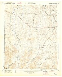
 1936 Bedford1936 Print · USGSBedford and the surrounding Tennessee countryside are captured in the mid-1930s just as the Tennessee Valley Authority began its regional surveys. Researchers can locate many vanished family landmarks and community hubs, including Pisgah Cem, New Bethel Ch, and Powell Creek Sch.
 - 1936 Map of Glendale
 1936 Glendale1936 Print · USGSMaury County during the mid-1930s reveals a landscape defined by the winding loops of the Duck River and a dense network of family-named landmarks. Genealogists and local historians can trace legacy sites like Hardison Cem, Union Grove Sch, and the old Scribners Mill Bridge.
 - 1944 Map of Shelbyville
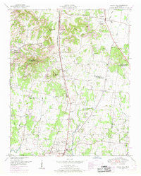
 1944 Shelbyville1944 Print · USGSMid-century Middle Tennessee is captured here during the wartime mobilization of the 1940s. Genealogists and researchers can trace family lands near Bugscuffle, Shelbyville Mills, and the expansive Camp Forrest Military Res.
 - 1946 Map of Brick Church, 1981 Print
 1946 Brick Church1981 Print · USGSGiles and Marshall Counties are captured here in the mid-1940s, showcasing a landscape of small rural hamlets and deeply established family cemeteries. Researchers can trace the grounds of Odd Fellows Hall, locate family plots at Kincaid Cem, or find the old Taylor Sch.
 - 1947 Map of Glendale, 1948 Print
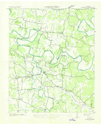
 1947 Glendale1948 Print · USGSThe Duck River country of Maury County is captured here just after the war, showing a landscape defined by deep river bends and rural rail stops. Genealogists can locate dozens of family burial sites like Tankersley Cem and trace the Louisville & Nashville tracks through Park Station.6 unique versions available
 - 1947 Map of Farmington, 1948 Print
 1947 Farmington1948 Print · USGSThe Duck River and the Louisville and Nashville RR shape this Marshall County landscape in the late 1940s. Genealogists can locate family names at Wilhoite Cem or trace the river at White Ford and Wilhoite Mills.4 unique versions available
 - 1947 Map of Bedford, 1948 Print
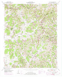
 1947 Bedford1948 Print · USGSThe rural landscape of Middle Tennessee is captured here in the late 1940s, highlighting a network of small farming settlements and river crossings. Researchers can trace family history through sites like Temple Ford, Richmond Ch, and the numerous community burial grounds like Gaunt Cem.6 unique versions available
 - 1947 Map of Rally Hill, 1948 Print
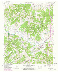
 1947 Rally Hill1948 Print · USGSMid-century Middle Tennessee comes to life in this survey of the Maury and Williamson county line. Genealogists can trace family roots through dozens of sites like Derryberry Cem or visit vanished crossroads like Rally Hill and Lunns Store.4 unique versions available
 - 1947 Map of Verona, 1948 Print
 1947 Verona1948 Print · USGSMarshall and Maury counties in the late 1940s were defined by the winding course of the Duck River and its rural mill seats. Researchers can trace family homesteads near Verona, old burial sites like Lillard Cem, and river landmarks such as Lillard Mill.6 unique versions available
 - 1949 Map of Brick Church
 1949 Brick Church1949 Print · USGSGiles and Marshall counties appear here in the late 1940s, showing a rural landscape defined by ridge-and-hollow farming and small schoolhouse districts. Genealogists can trace family names through numerous sites like Lane Cem, Odd Fellows Hall, and New Zion Ch.3 unique versions available
 - 1949 Map of Chapel Hill, 1966 Print
 1949 Chapel Hill1966 Print · USGSMid-century Middle Tennessee comes to life here as the rail-and-road network connects rural Marshall and Rutherford counties. Genealogists can trace family landmarks across dozens of sites like Riggs Chapel, Holtland (PO), and the Marrs Hill Cem.2 unique versions available
 - 1949 Map of Belleville, 1974 Print
 1949 Belleville1974 Print · USGSLincoln County was a landscape of high ridges and deep hollows in the years following the war, centered around the community of Belleville. Researchers can trace old family burial grounds and country parishes like Hickory Hill Church and Wylie Cemetery.2 unique versions available
 - 1949 Map of Belfast, 1975 Print
 1949 Belfast1975 Print · USGSMarshall County in the late nineteen-forties is a landscape of rural schoolhouses and family cemeteries connected by the Louisville and Nashville RR. Genealogists can trace family lines near Belfast through local landmarks like Temple Cem and Cedar Grove School.2 unique versions available
 - 1949 Map of Campbells Station, 1982 Print
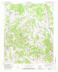 1949 Campbells Station1982 Print · USGSMid-century Tennessee hill country comes alive here as the LOUISVILLE AND NASHVILLE railroad winds through the ridges of Maury and Marshall counties. Genealogists and historians can trace family landholdings via dozens of sites like Shahe Cem, Mooresville School, and Dodson Siding.
Showing maps 1-25 of 102
Top cities of Marshall County
Frequently asked questions
- What are the different types of historical maps available for Marshall County?
- What is the oldest map of Marshall County?
- Where can I purchase historical maps of Marshall County for my home or office?
- Where can I download high-res historical maps of Marshall County?
- Are there historical topographic maps available for Marshall County?
- Is there historical aerial imagery available for Marshall County?
- Where are historical maps of Marshall County sourced from?