
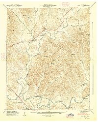
1936 Map of Belleville
USGS Topo · Published 1936About this map
Elk River winds along the northern boundary of this 1936 survey, which documents the complex borderlands where Lincoln, Moore, Marshall, and Bedford counties meet. The landscape is defined by the sharp transition between the upland Elk Ridge and the dense network of hollows and creeks to the south, such as Cane Creek and Mulberry Creek. The Tennessee Valley Authority, under chairman Arthur E. Morgan, directed this field examination to record rural infrastructure, including early transmission lines from the Duck River Electric Membership Corp. Small communities like Belleville and Bledsoe serve as anchors for a territory rich in genealogy, featuring numerous country sanctuaries such as Hannah Gap Ch and family burying grounds like Foster Cem. The map reveals a pre-modern road system, centered on State Highway No 10, before later development altered these traditional drainage basins.
Find a feature on this map
53 named features on this map. Tap any name to fly to it.
Don’t see what you’re looking for? This feature index may not catch every label — zoom into the map to look around manually.
Map Details
Editions of this 1936 Belleville Map
This is the sole edition of this map. No revisions or reprints were ever made.
Other maps of this area

1936 · Booneville
USGS Topo · 1:24,000

1936 · Shelbyville
USGS Topo · 1:24,000

1936 · Belfast
USGS Topo · 1:24,000

1936 · Boonshill
USGS Topo · 1:24,000

1936 · Petersburg
USGS Topo · 1:24,000

1936 · Bedford
USGS Topo · 1:24,000

1936 · Mulberry
USGS Topo · 1:24,000

1936 · Fayetteville
USGS Topo · 1:24,000

1944 · Shelbyville
USGS Topo · 1:100,000
1947 · Mulberry
USGS Topo · 1:24,000