1930s Maps of Athens, Tennessee
Explore 3 historic maps of Athens from the 1930s. These maps offer a rare glimpse into what life looked like during the 1930s — showing old roads, neighborhoods, homes, and landmarks that have changed or disappeared over time.
Whether you're researching your family's past, planning a metal detecting trip, or studying how Athens's landscape evolved across the 1930s, these high-resolution maps are a powerful tool for exploring the history of this region.
- Focus on a specific era: All maps on this page are from the 1930s, giving you a focused view of this time period.
- See what’s changed: Compare century-old streets, trails, and buildings to today's modern landscape using overlays and satellite layers.
- Research with precision: Use these maps for genealogy, historical research, land use analysis, or educational projects.
- View, download, or print: Maps are fully viewable online in high resolution, and can be downloaded or printed for your own records.
Start exploring Athens's history through authentic maps from the 1930s. This is your window into the past.
Athens, TN maps
(3)- 1935 Map of Niota
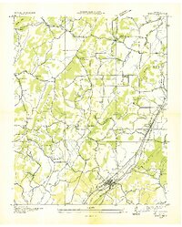 1935 Niota1935 Print · USGSNiota and the surrounding McMinn County countryside are shown here in the mid-1930s as the rail and highway network began to modernize the region. Researchers can locate early rural landmarks like Murphys Store, the Flume Mill, and several country schools including Pine Grove Sch.
 - 1935 Map of Athens
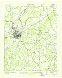 1935 Athens1935 Print · USGSMid-1930s McMinn County reveals a landscape where traditional crossroads and the emerging power grid meet. Trace family roots through local landmarks like Cedar Springs Cem, Simons Chapel, and the historic railroad junction at Athens.
 - 1935 Map of Riceville
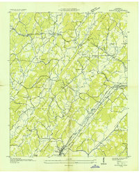 1935 Riceville1935 Print · USGSMcMinn County was a landscape in transition in the mid-1930s, as the Southern Railway and new power lines moved through its rural valleys. Genealogists and historians can trace local landmarks like Riceville, the Barite Mine, and the CCC Camp.
End of results
Showing maps 1-3 of 3
Top cities near Athens
- Sweetwater historical maps
- Madisonville historical maps
- Etowah historical maps
- Englewood historical maps
- Decatur historical maps
- Niota historical maps
See more
Top neighborhoods of Athens
- Morningside historical maps
- Prof Park historical maps
- Ridgeway historical maps
- Bohannon Addition historical maps
- Sunset View historical maps
- Tellico Hills historical maps
See more
Frequently asked questions
- What are the different types of historical maps available for Athens?
- What is the oldest map of Athens?
- Where can I purchase historical maps of Athens for my home or office?
- Where can I download high-res historical maps of Athens?
- Are there historical topographic maps available for Athens?
- Is there historical aerial imagery available for Athens?
- Where are historical maps of Athens sourced from?