1960s Maps of Athens, Tennessee
Explore 4 historic maps of Athens from the 1960s. These maps offer a rare glimpse into what life looked like during the 1960s — showing old roads, neighborhoods, homes, and landmarks that have changed or disappeared over time.
Whether you're researching your family's past, planning a metal detecting trip, or studying how Athens's landscape evolved across the 1960s, these high-resolution maps are a powerful tool for exploring the history of this region.
- Focus on a specific era: All maps on this page are from the 1960s, giving you a focused view of this time period.
- See what’s changed: Compare century-old streets, trails, and buildings to today's modern landscape using overlays and satellite layers.
- Research with precision: Use these maps for genealogy, historical research, land use analysis, or educational projects.
- View, download, or print: Maps are fully viewable online in high resolution, and can be downloaded or printed for your own records.
Start exploring Athens's history through authentic maps from the 1960s. This is your window into the past.
Athens, TN maps
(4)- 1960 Map of Chattanooga
 1960 Chattanooga1960 Print · USGSSoutheast Tennessee and the southern Appalachians are shown here at the height of the river-management era. You can trace the valley rail lines and locate Lookout Mountain and the expansive waters of Chickamauga Reservoir.
 - 1964 Map of Chattanooga
 1964 Chattanooga1964 Print · USGSSoutheast Tennessee and the western Carolinas appear in the mid-sixties as a powerhouse of river-driven industry and mountain wilderness. Genealogists and historians can trace rail-town lineages along the Southern Ry or locate family landmarks near Watts Bar Lake and Tellico Plains.
 - 1964 Map of Athens, 1966 Print
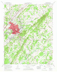 1964 Athens1966 Print · USGSAthens in the mid-sixties shows a classic Tennessee rail town evolving into a modern regional center. Genealogists and researchers can locate numerous family landmarks like Cedar Grove Cem, Tennessee Wesleyan College, and the old Antioch Church.5 unique versions available
 - 1964 Map of Riceville, 1966 Print
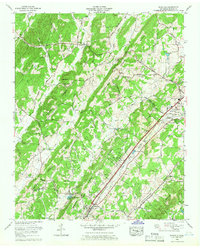 1964 Riceville1966 Print · USGSMcMinn County in the mid-1960s was a landscape of prominent ridges and valley railways connecting Riceville to the outskirts of Athens. Researchers can find many family landmarks and rural centers like Lillard Cem, Idlewild, and the Fish Hatchery.3 unique versions available
End of results
Showing maps 1-4 of 4
Top cities near Athens
- Sweetwater historical maps
- Madisonville historical maps
- Etowah historical maps
- Englewood historical maps
- Decatur historical maps
- Niota historical maps
See more
Top neighborhoods of Athens
- Morningside historical maps
- Prof Park historical maps
- Ridgeway historical maps
- Bohannon Addition historical maps
- Sunset View historical maps
- Tellico Hills historical maps
See more
Frequently asked questions
- What are the different types of historical maps available for Athens?
- What is the oldest map of Athens?
- Where can I purchase historical maps of Athens for my home or office?
- Where can I download high-res historical maps of Athens?
- Are there historical topographic maps available for Athens?
- Is there historical aerial imagery available for Athens?
- Where are historical maps of Athens sourced from?