1940s Maps of Double Springs, Tennessee
Explore 2 historic maps of Double Springs from the 1940s. These maps offer a rare glimpse into what life looked like during the 1940s — showing old roads, neighborhoods, homes, and landmarks that have changed or disappeared over time.
Whether you're researching your family's past, planning a metal detecting trip, or studying how Double Springs's landscape evolved across the 1940s, these high-resolution maps are a powerful tool for exploring the history of this region.
- Focus on a specific era: All maps on this page are from the 1940s, giving you a focused view of this time period.
- See what’s changed: Compare century-old streets, trails, and buildings to today's modern landscape using overlays and satellite layers.
- Research with precision: Use these maps for genealogy, historical research, land use analysis, or educational projects.
- View, download, or print: Maps are fully viewable online in high resolution, and can be downloaded or printed for your own records.
Start exploring Double Springs's history through authentic maps from the 1940s. This is your window into the past.
Double Springs, TN maps
(2)- 1943 Map of Calhoun, 1960 Print
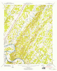 1943 Calhoun1960 Print · USGSThe Hiwassee River valley at the onset of the 1940s reveals a rural landscape of ridges and river bends at the borders of McMinn and Bradley counties. Genealogists and historians can trace family locations near Whites Mill, Gentry Store, and the Womack Cem.2 unique versions available
 - 1944 Map of Calhoun, 1946 Print
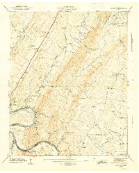 1944 Calhoun1946 Print · USGSThe Hiwassee River corridor in the 1940s reveals a landscape of river bends and rural crossroads. Local historians can trace the foundations of the community at Whites Mill, the small rail siding at Sanford, and early schools like Claxton Sch.2 unique versions available
End of results
Showing maps 1-2 of 2
Top cities near Double Springs
- Cleveland historical maps
- Athens historical maps
- Etowah historical maps
- Englewood historical maps
- Decatur historical maps
- Benton historical maps
See more
Frequently asked questions
- What are the different types of historical maps available for Double Springs?
- What is the oldest map of Double Springs?
- Where can I purchase historical maps of Double Springs for my home or office?
- Where can I download high-res historical maps of Double Springs?
- Are there historical topographic maps available for Double Springs?
- Is there historical aerial imagery available for Double Springs?
- Where are historical maps of Double Springs sourced from?