1940s Maps of Piney Grove, Tennessee
Explore 2 historic maps of Piney Grove from the 1940s. These maps offer a rare glimpse into what life looked like during the 1940s — showing old roads, neighborhoods, homes, and landmarks that have changed or disappeared over time.
Whether you're researching your family's past, planning a metal detecting trip, or studying how Piney Grove's landscape evolved across the 1940s, these high-resolution maps are a powerful tool for exploring the history of this region.
- Focus on a specific era: All maps on this page are from the 1940s, giving you a focused view of this time period.
- See what’s changed: Compare century-old streets, trails, and buildings to today's modern landscape using overlays and satellite layers.
- Research with precision: Use these maps for genealogy, historical research, land use analysis, or educational projects.
- View, download, or print: Maps are fully viewable online in high resolution, and can be downloaded or printed for your own records.
Start exploring Piney Grove's history through authentic maps from the 1940s. This is your window into the past.
Piney Grove, TN maps
(2)- 1943 Map of Etowah, 1960 Print
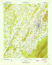 1943 Etowah1960 Print · USGSMcMinn County in the early 1940s centers on the bustling rail hub of Etowah as it expands along the Louisville and Nashville line. Genealogists and historians can trace family locations at rural landmarks like Old Salem Ch, Gravel Hill Sch, and the Buttram Cem.2 unique versions available
 - 1944 Map of Etowah, 1946 Print
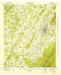 1944 Etowah1946 Print · USGSMcMinn County in the mid-1940s reveals a landscape defined by the Louisville and Nashville railroad and rural life. Researchers can trace family roots at Buttram Cem or locate vanished schools like Wesleyana Sch.
End of results
Showing maps 1-2 of 2
Top cities near Piney Grove
- Cleveland historical maps
- Athens historical maps
- Sweetwater historical maps
- Madisonville historical maps
- Etowah historical maps
- Englewood historical maps
See more
Frequently asked questions
- What are the different types of historical maps available for Piney Grove?
- What is the oldest map of Piney Grove?
- Where can I purchase historical maps of Piney Grove for my home or office?
- Where can I download high-res historical maps of Piney Grove?
- Are there historical topographic maps available for Piney Grove?
- Is there historical aerial imagery available for Piney Grove?
- Where are historical maps of Piney Grove sourced from?