1940s Maps of Tranquillity, Tennessee
Explore 2 historic maps of Tranquillity from the 1940s. These maps offer a rare glimpse into what life looked like during the 1940s — showing old roads, neighborhoods, homes, and landmarks that have changed or disappeared over time.
Whether you're researching your family's past, planning a metal detecting trip, or studying how Tranquillity's landscape evolved across the 1940s, these high-resolution maps are a powerful tool for exploring the history of this region.
- Focus on a specific era: All maps on this page are from the 1940s, giving you a focused view of this time period.
- See what’s changed: Compare century-old streets, trails, and buildings to today's modern landscape using overlays and satellite layers.
- Research with precision: Use these maps for genealogy, historical research, land use analysis, or educational projects.
- View, download, or print: Maps are fully viewable online in high resolution, and can be downloaded or printed for your own records.
Start exploring Tranquillity's history through authentic maps from the 1940s. This is your window into the past.
Tranquillity, TN maps
(2)- 1941 Map of Tranquillity, 1960 Print
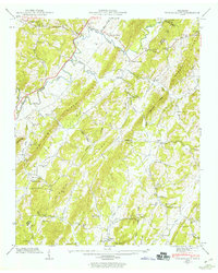 1941 Tranquillity1960 Print · USGSMcMinn County was a landscape of ridge-top lookouts and valley farms in the early 1940s, shortly after the Tennessee Valley Authority began its local survey. Researchers can locate vanished landmarks like Collins Mill and the Old Walnut Grove Cem, or trace the old roads connecting Tranquillity to Fiketon.2 unique versions available
 - 1942 Map of Tranquillity
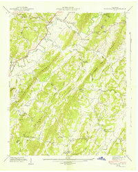 1942 Tranquillity1942 Print · USGSMcMinn County at the start of the 1940s reveals a landscape of ridge-and-valley farms and tight-knit rural communities. Genealogists can trace family roots through several schools and churches, such as Turkeypen Sch, Collins Mill, and Hutsell Cem.
End of results
Showing maps 1-2 of 2
Top cities near Tranquillity
- Athens historical maps
- Sweetwater historical maps
- Etowah historical maps
- Spring City historical maps
- Englewood historical maps
- Decatur historical maps
See more
Frequently asked questions
- What are the different types of historical maps available for Tranquillity?
- What is the oldest map of Tranquillity?
- Where can I purchase historical maps of Tranquillity for my home or office?
- Where can I download high-res historical maps of Tranquillity?
- Are there historical topographic maps available for Tranquillity?
- Is there historical aerial imagery available for Tranquillity?
- Where are historical maps of Tranquillity sourced from?