1930s Maps of Adamsville, Tennessee
Explore 4 historic maps of Adamsville from the 1930s. These maps offer a rare glimpse into what life looked like during the 1930s — showing old roads, neighborhoods, homes, and landmarks that have changed or disappeared over time.
Whether you're researching your family's past, planning a metal detecting trip, or studying how Adamsville's landscape evolved across the 1930s, these high-resolution maps are a powerful tool for exploring the history of this region.
- Focus on a specific era: All maps on this page are from the 1930s, giving you a focused view of this time period.
- See what’s changed: Compare century-old streets, trails, and buildings to today's modern landscape using overlays and satellite layers.
- Research with precision: Use these maps for genealogy, historical research, land use analysis, or educational projects.
- View, download, or print: Maps are fully viewable online in high resolution, and can be downloaded or printed for your own records.
Start exploring Adamsville's history through authentic maps from the 1930s. This is your window into the past.
Adamsville, TN maps
(4)- 1936 Map of Leapwood
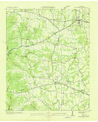
 1936 Leapwood1936 Print · USGSMcNairy County communities and Tennessee Valley Authority power projects are captured here in the mid-1930s. Trace local family history through numerous schools and churches like Leapwood Sch, Mars Hill Ch, and Hardin Beauty Sch.
 - 1936 Map of Milledgeville
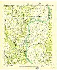
 1936 Milledgeville1936 Print · USGSNear the Tennessee River in the mid-1930s, this area of West Tennessee reveals a landscape shaped by river landings and extensive drainage projects. Genealogists and historians can trace community roots through Sweeney Cem, Morris Chapel, and schools like Rock Spring Sch.
 - 1936 Map of Pittsburg Landing
 1936 Pittsburg Landing1936 Print · USGSHardin County during the mid-1930s shows a landscape defined by the Tennessee River and the grounds of Shiloh National Military Park. Researchers can trace early river crossings like Pittsburg Ferry and find vanished landmarks like CCC Camp No 2425.
 - 1936 Map of Stantonville
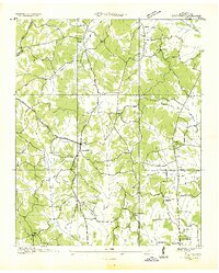
 1936 Stantonville1936 Print · USGSMcNairy County during the mid-thirties reveals a landscape of small farming communities and early TVA infrastructure projects. Researchers can trace rural school locations like Lawton Sch, family burial grounds such as Combs Cem, and the early layout of Adamsville.
End of results
Showing maps 1-4 of 4
Top cities near Adamsville
- Savannah historical maps
- Henderson historical maps
- Selmer historical maps
- Crump historical maps
- Bethel Springs historical maps
- Michie historical maps
See more
Top neighborhoods of Adamsville
Frequently asked questions
- What are the different types of historical maps available for Adamsville?
- What is the oldest map of Adamsville?
- Where can I purchase historical maps of Adamsville for my home or office?
- Where can I download high-res historical maps of Adamsville?
- Are there historical topographic maps available for Adamsville?
- Is there historical aerial imagery available for Adamsville?
- Where are historical maps of Adamsville sourced from?