1930s Maps of Madisonville, Tennessee
Explore 5 historic maps of Madisonville from the 1930s. These maps offer a rare glimpse into what life looked like during the 1930s — showing old roads, neighborhoods, homes, and landmarks that have changed or disappeared over time.
Whether you're researching your family's past, planning a metal detecting trip, or studying how Madisonville's landscape evolved across the 1930s, these high-resolution maps are a powerful tool for exploring the history of this region.
- Focus on a specific era: All maps on this page are from the 1930s, giving you a focused view of this time period.
- See what’s changed: Compare century-old streets, trails, and buildings to today's modern landscape using overlays and satellite layers.
- Research with precision: Use these maps for genealogy, historical research, land use analysis, or educational projects.
- View, download, or print: Maps are fully viewable online in high resolution, and can be downloaded or printed for your own records.
Start exploring Madisonville's history through authentic maps from the 1930s. This is your window into the past.
Madisonville, TN maps
(5)- 1934 Map of Mount Vernon
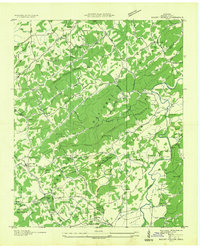 1934 Mount Vernon1934 Print · USGSMonroe County mountain life in the mid-1930s centered on the ridges of the Cherokee National Forest and the banks of the Tellico River. Genealogists can trace early homesteads and community hubs like Belltown P O, Stakely Mill, and the Old Prospect Cem.
 - 1934 Map of Englewood
 1934 Englewood1934 Print · USGSIn the mid-1930s, the McMinn County countryside was a network of rail-side settlements and upland farms. Genealogists can trace family footprints through numerous rural landmarks like Isbell Cem, McConkey Sch, and New Bethel Ch.
 - 1935 Map of Tellico
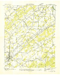
 1935 Tellico1935 Print · USGSMonroe County was a landscape of mountain ridges and remote outposts in the mid-1930s, anchored by the rail hub at Tellico Plains. Genealogists and researchers can trace family landmarks like Carpenter Cem, Oldman Mill, and the Rural Vale School.
 - 1936 Map of Madisonville
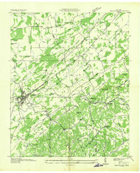
 1936 Madisonville1936 Print · USGSMadisonville and the surrounding Monroe County countryside are captured here during the transformative mid-thirties era of rural electrification. Researchers can trace the grounds of Hiwassee College or locate vanished local landmarks like Hopewell Springs and Sequoyah Sch.
 - 1936 Map of Sweetwater
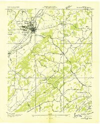 1936 Sweetwater1936 Print · USGSSweetwater and the surrounding valley are shown here in the mid-1930s as the Tennessee Valley Authority began its regional work. Researchers can locate numerous vanished rural landmarks, including Tennessee Military Institute, Christianburg, and schools like High Point Sch and Liberality Sch.
End of results
Showing maps 1-5 of 5
Top cities near Madisonville
- Athens historical maps
- Tellico Village historical maps
- Loudon historical maps
- Sweetwater historical maps
- Etowah historical maps
- Englewood historical maps
See more
Top neighborhoods of Madisonville
Frequently asked questions
- What are the different types of historical maps available for Madisonville?
- What is the oldest map of Madisonville?
- Where can I purchase historical maps of Madisonville for my home or office?
- Where can I download high-res historical maps of Madisonville?
- Are there historical topographic maps available for Madisonville?
- Is there historical aerial imagery available for Madisonville?
- Where are historical maps of Madisonville sourced from?