1930s Maps of Lynchburg, Tennessee
Explore 8 historic maps of Lynchburg from the 1930s. These maps offer a rare glimpse into what life looked like during the 1930s — showing old roads, neighborhoods, homes, and landmarks that have changed or disappeared over time.
Whether you're researching your family's past, planning a metal detecting trip, or studying how Lynchburg's landscape evolved across the 1930s, these high-resolution maps are a powerful tool for exploring the history of this region.
- Focus on a specific era: All maps on this page are from the 1930s, giving you a focused view of this time period.
- See what’s changed: Compare century-old streets, trails, and buildings to today's modern landscape using overlays and satellite layers.
- Research with precision: Use these maps for genealogy, historical research, land use analysis, or educational projects.
- View, download, or print: Maps are fully viewable online in high resolution, and can be downloaded or printed for your own records.
Start exploring Lynchburg's history through authentic maps from the 1930s. This is your window into the past.
Lynchburg, TN maps
(8)- 1936 Map of Booneville
 1936 Booneville1936 Print · USGSThe rural borderlands of Moore, Lincoln, and Bedford counties are captured here in the mid-1930s during a period of steady local development. Researchers can pinpoint early community hubs like Screamersville, Charity Sch, and the river crossing at Booneville.
 - 1936 Map of Cumberland Springs
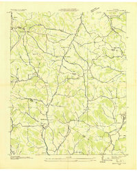
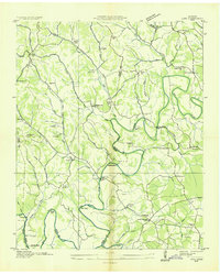
 1936 Cumberland Springs1936 Print · USGSMoore County and Lynchburg are captured in the mid-1930s as a land of narrow hollows and high ridges. Researchers can trace the early layout of Lynchburg and find community centers like Raysville Sch, Smith Chapel, and Cumberland Springs.
 - 1936 Map of Belleville
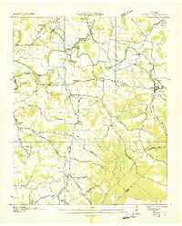
 1936 Belleville1936 Print · USGSLincoln County and the surrounding borderlands are captured here in the mid-1930s, showing a rural landscape organized around deep hollows and creek branches. Researchers can locate numerous local landmarks including Oak Hill Ch, Patton Cem, and the settlement of Belleville.
 - 1936 Map of Huntland
 1936 Huntland1936 Print · USGSFranklin County's rail-and-mill economy is on full display in the mid-thirties as the Nashville Chattanooga and St Louis Ry connects Huntland and Elora. Researchers can trace the heritage of rural communities through sites like Stonewall Mill, Simmons Chapel, and the Mc Clure Cem.
 - 1936 Map of Mulberry
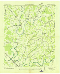 1936 Mulberry1936 Print · USGSMiddle Tennessee's river valleys come alive in the mid-1930s, showing the early reach of the TVA and the local rail network. Trace the paths to Lockes Mill, Lloyd Chapel, and family sites like Cowley Cem or Smith Cem.
 - 1936 Map of Camp Peay
 1936 Camp Peay1936 Print · USGSIn the mid-1930s, the area around Tullahoma and Estill Springs was a hub of military and rail activity. Genealogists and historians can trace the National Guard Reservation at Camp Peay, family burial sites like Maplewood Cem, and local landmarks including the Girls Vocational Sch.
 - 1936 Map of Normandy
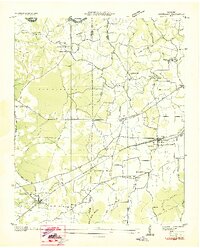
 1936 Normandy1936 Print · USGSBedford and Moore counties come to life in the 1930s as the rail-and-river economy centers on the town of Normandy. Genealogists and historians can trace family locations at Bugscuffle, locate Jenkins Sch, or find industrial landmarks like Cortners Mill.
 - 1936 Map of Lois
 1936 Lois1936 Print · USGSMoore County at the start of the Tennessee Valley Authority era shows a landscape of river-bend farms and scattered crossroads settlements. Genealogists can locate family-named landmarks such as Gray Cem, Browningtown, and the Liberty Hill Sch along the Elk River.
End of results
Showing maps 1-8 of 8
Top cities near Lynchburg
- Shelbyville historical maps
- Tullahoma historical maps
- Fayetteville historical maps
- Estill Springs historical maps
- Huntland historical maps
- Normandy historical maps
Top neighborhoods of Lynchburg
- Bakertown historical maps
- Pleasant Hill historical maps
- Countyline historical maps
- Raysville historical maps
- Ridgeville historical maps
- Turkey Creek historical maps
See more
Frequently asked questions
- What are the different types of historical maps available for Lynchburg?
- What is the oldest map of Lynchburg?
- Where can I purchase historical maps of Lynchburg for my home or office?
- Where can I download high-res historical maps of Lynchburg?
- Are there historical topographic maps available for Lynchburg?
- Is there historical aerial imagery available for Lynchburg?
- Where are historical maps of Lynchburg sourced from?