1960s Maps of Obion County, Tennessee
Explore 12 historic maps of Obion County from the 1960s. These maps offer a rare glimpse into what life looked like during the 1960s — showing old roads, neighborhoods, homes, and landmarks that have changed or disappeared over time.
Whether you're researching your family's past, planning a metal detecting trip, or studying how Obion County's landscape evolved across the 1960s, these high-resolution maps are a powerful tool for exploring the history of this region.
- Focus on a specific era: All maps on this page are from the 1960s, giving you a focused view of this time period.
- See what’s changed: Compare century-old streets, trails, and buildings to today's modern landscape using overlays and satellite layers.
- Research with precision: Use these maps for genealogy, historical research, land use analysis, or educational projects.
- View, download, or print: Maps are fully viewable online in high resolution, and can be downloaded or printed for your own records.
Start exploring Obion County's history through authentic maps from the 1960s. This is your window into the past.
Obion County, TN maps
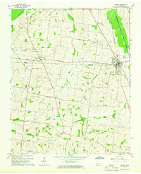
(12)- 1961 Map of Dyersburg, 1965 Print
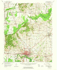 1961 Dyersburg1965 Print · USGSDyer County at the start of the sixties reveals a thriving rail-and-river hub centered on the growing city of Dyersburg. Researchers can trace family roots through numerous rural landmarks like Bruces Chapel, Cloverdale Sch, and the Newbern Cem.
 - 1964 Map of Tiptonville, 1965 Print
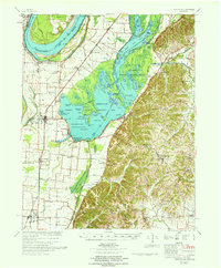
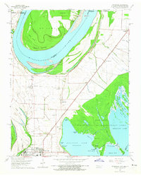 1964 Tiptonville1965 Print · USGSTiptonville and the Mississippi River bottoms are captured in the mid-sixties, showing a landscape defined by shifting river channels and the waters of Reelfoot Lake. Genealogists can locate family sites like Cronanville Cem, Mt Zion Ch, and the Indian Mound.2 unique versions available
 - 1964 Map of Samburg, 1965 Print
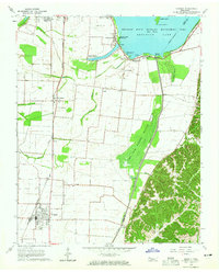
 1964 Samburg1965 Print · USGSReelfoot Lake and the surrounding bottomlands are captured here in the mid-1960s as both a refuge and a living community. Genealogists and local historians can trace the roads connecting Samburg, Walnut Log, and Roneys Store, or locate family sites near Midway Ch and Mt Zion Ch.2 unique versions available
 - 1964 Map of Ridgely, 1965 Print
 1964 Ridgely1965 Print · USGSMid-century Lake County comes to life as a network of wetland refuges and agricultural rail towns before modern landscape changes. Genealogists can locate family sites at New Haven Cem and Crocketts Chapel, or trace the tracks of the Illinois Central through Ridgely and Wynnburg.2 unique versions available
 - 1964 Map of Hornbeak, 1965 Print
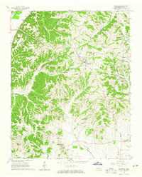 1964 Hornbeak1965 Print · USGSObion County's eastern bluff lands near the Reelfoot basin appear here in the mid-1960s. Genealogists can trace family connections through sites like Thompson Cem, Minnick Cem, and small settlements including Jacksonville and Glass.3 unique versions available
 - 1965 Map of Kenton, 1966 Print
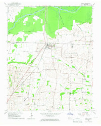
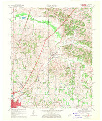
 1965 Kenton1966 Print · USGSThe West Tennessee borderlands of Obion and Gibson counties are captured here in the mid-sixties, centered on the railroad town of Kenton. Local historians can trace old community hubs like Mason Hall, Tyson Store, and family landmarks including Sunny Side Cem.2 unique versions available
 - 1965 Map of Trimble, 1967 Print
 1965 Trimble1967 Print · USGSThe Dyer and Obion County line in the mid-1960s shows a landscape of river-bottom drainage and rail-side commerce. Genealogists can trace family names at Pierce Cem and McCorkle Cem or locate rural centers like Harmony Ch and Templeton.2 unique versions available
 - 1966 Map of Clayton, 1968 Print
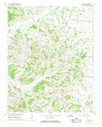 1966 Clayton1968 Print · USGSObion County's rolling landscape near the Kentucky border is captured here in the mid-1960s, showing a network of rural communities and church-centered settlements. Genealogists can trace family roots through sites like Old Republican Ch, the County Home, and the namesake village of Clayton.2 unique versions available
 - 1967 Map of Reelfoot Lake
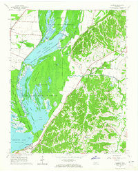
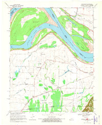
 1967 Reelfoot Lake1967 Print · USGSReelfoot Lake and the Mississippi riverfront are captured here in the mid-sixties, showing a landscape defined by wetlands and rail-line towns. Researchers can trace family sites at Owl City or Samburg, and locate landmarks like Mt Zion Ch and Oak Ridge Sch.
 - 1969 Map of Water Valley, 1971 Print
 1969 Water Valley1971 Print · USGSThe Kentucky and Tennessee borderlands are captured here in the late sixties as the new parkway system began to reshape the rural landscape. Researchers can trace family history at Wesley Cem and Boaz Chapel or explore the site of Camp Beauregard near Water Valley.2 unique versions available
 - 1969 Map of Crutchfield, 1971 Print
 1969 Crutchfield1971 Print · USGSCrossing the Kentucky-Tennessee border in the late 1960s, this survey highlights the bustling rail-and-river geography near the state line. Genealogists can trace family names through landmarks like Riceville, Crossland Cem, and Mt Carmel Ch.
 - 1969 Map of Bondurant, 1972 Print
 1969 Bondurant1972 Print · USGSThe tri-state border region of Kentucky, Missouri, and Tennessee comes alive in this late-sixties study of the Mississippi river bends. Genealogists can locate family landmarks like Sassafras Ridge Ch, Western Sch, and the Indian Mound.2 unique versions available
End of results
Showing maps 1-12 of 12
Top cities of Obion County
- Union City historical maps
- South Fulton historical maps
- Troy historical maps
- Obion historical maps
- Hornbeak historical maps
- Rives historical maps
See more
Frequently asked questions
- What are the different types of historical maps available for Obion County?
- What is the oldest map of Obion County?
- Where can I purchase historical maps of Obion County for my home or office?
- Where can I download high-res historical maps of Obion County?
- Are there historical topographic maps available for Obion County?
- Is there historical aerial imagery available for Obion County?
- Where are historical maps of Obion County sourced from?