1950s Maps of Pigeon Forge, Tennessee
Explore 4 historic maps of Pigeon Forge from the 1950s. These maps offer a rare glimpse into what life looked like during the 1950s — showing old roads, neighborhoods, homes, and landmarks that have changed or disappeared over time.
Whether you're researching your family's past, planning a metal detecting trip, or studying how Pigeon Forge's landscape evolved across the 1950s, these high-resolution maps are a powerful tool for exploring the history of this region.
- Focus on a specific era: All maps on this page are from the 1950s, giving you a focused view of this time period.
- See what’s changed: Compare century-old streets, trails, and buildings to today's modern landscape using overlays and satellite layers.
- Research with precision: Use these maps for genealogy, historical research, land use analysis, or educational projects.
- View, download, or print: Maps are fully viewable online in high resolution, and can be downloaded or printed for your own records.
Start exploring Pigeon Forge's history through authentic maps from the 1950s. This is your window into the past.
Pigeon Forge, TN maps
(4)- 1953 Map of Walden Creek, 1955 Print
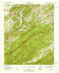 1953 Walden Creek1955 Print · USGSSevier County in the early fifties shows a landscape of deep hollows and high ridges before the era of modern development. Genealogists can trace family roots through numerous mountain churches and schools like Antioch Church, Benson School, and Ivy Hill Cemetery.4 unique versions available
 - 1955 Map of Knoxville
 1955 Knoxville1955 Print · USGSThe Southern Appalachians and the Smoky Mountains are shown here at a peak of mid-century development and conservation. Genealogists and historians can trace the early road networks connecting Gatlinburg, Waynesville, and the Cherokee Indian Reservation across the high ridges.
 - 1956 Map of Pigeon Forge, 1958 Print
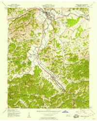 1956 Pigeon Forge1958 Print · USGSSevier County was undergoing a significant shift toward modern tourism during the 1950s. Genealogists and local historians can trace family homesteads near Henderson Springs, locate old burials at Shiloh Mem Cem, or identify vanished landmarks like the Drive-in Theater.3 unique versions available
 - 1957 Map of Knoxville, 1966 Print
 1957 Knoxville1966 Print · USGSThe Southern Appalachians of Tennessee and North Carolina are mapped here during the mid-twentieth century as new highways reached the high country. Genealogists and historians can trace the topography between Knoxville and Asheville, locating family landmarks near Fontana Lake or along the Blue Ridge Parkway.4 unique versions available
End of results
Showing maps 1-4 of 4
Top cities near Pigeon Forge
- Knoxville historical maps
- Sevierville historical maps
- Gatlinburg historical maps
- Dandridge historical maps
- Pittman Center historical maps
- Townsend historical maps
Top neighborhoods of Pigeon Forge
- Middle Creek historical maps
- Mount Zion historical maps
- Henderson Springs historical maps
- Pine Grove historical maps
- Waldens Creek historical maps
- Conner Heights historical maps
Frequently asked questions
- What are the different types of historical maps available for Pigeon Forge?
- What is the oldest map of Pigeon Forge?
- Where can I purchase historical maps of Pigeon Forge for my home or office?
- Where can I download high-res historical maps of Pigeon Forge?
- Are there historical topographic maps available for Pigeon Forge?
- Is there historical aerial imagery available for Pigeon Forge?
- Where are historical maps of Pigeon Forge sourced from?