1940s Maps of Pigeon Forge, Tennessee
Explore 2 historic maps of Pigeon Forge from the 1940s. These maps offer a rare glimpse into what life looked like during the 1940s — showing old roads, neighborhoods, homes, and landmarks that have changed or disappeared over time.
Whether you're researching your family's past, planning a metal detecting trip, or studying how Pigeon Forge's landscape evolved across the 1940s, these high-resolution maps are a powerful tool for exploring the history of this region.
- Focus on a specific era: All maps on this page are from the 1940s, giving you a focused view of this time period.
- See what’s changed: Compare century-old streets, trails, and buildings to today's modern landscape using overlays and satellite layers.
- Research with precision: Use these maps for genealogy, historical research, land use analysis, or educational projects.
- View, download, or print: Maps are fully viewable online in high resolution, and can be downloaded or printed for your own records.
Start exploring Pigeon Forge's history through authentic maps from the 1940s. This is your window into the past.
Pigeon Forge, TN maps
(2)- 1940 Map of Pigeon Forge
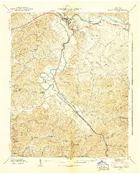 1940 Pigeon Forge1940 Print · USGSSevier County during the pre-war period shows the early development of Pigeon Forge and the established county seat at Sevierville. Genealogists and historians can trace family locations near Mc Mahan Cem, Henderson Springs, and the Williamsburg Sch.
 - 1941 Map of Walden Creek
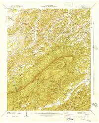 1941 Walden Creek1941 Print · USGSSevier County in the early 1940s is a landscape of mountain ridges and remote valley settlements. Genealogists can locate family landmarks like the Harrison Chilhowee Academy, Dupont Cem, and numerous rural schoolhouses such as Laurel Grove Sch.2 unique versions available
End of results
Showing maps 1-2 of 2
Top cities near Pigeon Forge
- Knoxville historical maps
- Sevierville historical maps
- Gatlinburg historical maps
- Dandridge historical maps
- Pittman Center historical maps
- Townsend historical maps
Top neighborhoods of Pigeon Forge
- Middle Creek historical maps
- Mount Zion historical maps
- Henderson Springs historical maps
- Pine Grove historical maps
- Waldens Creek historical maps
- Conner Heights historical maps
Frequently asked questions
- What are the different types of historical maps available for Pigeon Forge?
- What is the oldest map of Pigeon Forge?
- Where can I purchase historical maps of Pigeon Forge for my home or office?
- Where can I download high-res historical maps of Pigeon Forge?
- Are there historical topographic maps available for Pigeon Forge?
- Is there historical aerial imagery available for Pigeon Forge?
- Where are historical maps of Pigeon Forge sourced from?