1960s Maps of Lakeland, Tennessee
Explore 8 historic maps of Lakeland from the 1960s. These maps offer a rare glimpse into what life looked like during the 1960s — showing old roads, neighborhoods, homes, and landmarks that have changed or disappeared over time.
Whether you're researching your family's past, planning a metal detecting trip, or studying how Lakeland's landscape evolved across the 1960s, these high-resolution maps are a powerful tool for exploring the history of this region.
- Focus on a specific era: All maps on this page are from the 1960s, giving you a focused view of this time period.
- See what’s changed: Compare century-old streets, trails, and buildings to today's modern landscape using overlays and satellite layers.
- Research with precision: Use these maps for genealogy, historical research, land use analysis, or educational projects.
- View, download, or print: Maps are fully viewable online in high resolution, and can be downloaded or printed for your own records.
Start exploring Lakeland's history through authentic maps from the 1960s. This is your window into the past.
Lakeland, TN maps
(8)- 1960 Map of Bartlett, 1963 Print
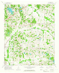
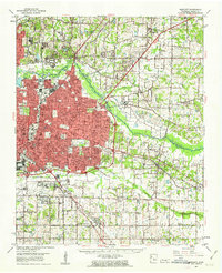 1960 Bartlett1963 Print · USGSShelby County enters a period of intense suburban growth during the early sixties as development pushes east toward Bartlett and Germantown. Genealogists and local historians can locate dozens of country landmarks, from the National Cem and National Cem to the Capleville Ch & Sch.
 - 1960 Map of Millington, 1963 Print
 1960 Millington1963 Print · USGSMillington and its surrounding farm country are shown here in the early sixties, highlighting a landscape defined by mid-century aviation and deep-rooted rural communities. Researchers can trace the sprawling U S Naval Air Technical Training Center or locate ancestral sites like Helen Crigger Cem and Temple Ch.
 - 1961 Map of Bartlett
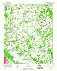
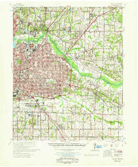 1961 Bartlett1961 Print · USGSShelby County transitions from rural farmland to suburban expansion as Memphis grows eastward in the early sixties. Researchers can trace family sites at Spring Hill Ch & Sch, the historic National Cem, and the old rail stop at Mullins Station Ch.
 - 1965 Map of Arlington, 1966 Print
 1965 Arlington1966 Print · USGSIn the mid-sixties, this section of West Tennessee centers on Arlington and its vital Louisville and Nashville Railroad corridor. Genealogists can locate family landmarks like Robinson Cem, Bethel Ch, and Barret Chapel High Sch.3 unique versions available
 - 1965 Map of Eads, 1966 Print
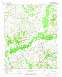
 1965 Eads1966 Print · USGSShelby and Fayette counties appear here in the mid-sixties, showing a landscape of rural crossroads and growing recreation lakes. Local historians can trace old family sites like Lea Union Cem or the rural commerce at Fisherville and Lenow.3 unique versions available
 - 1965 Map of Ellendale, 1967 Print
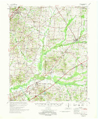
 1965 Ellendale1967 Print · USGSShelby County in the mid-sixties shows a landscape of growing communities and institutional land use at the edge of the Memphis metropolitan area. Researchers can trace the grounds of the County Penal Farm, find early schools like Blackwell High School, and locate rural landmarks such as Ellendale and Cordova.5 unique versions available
 - 1968 Map of Collierville
 1968 Collierville1968 Print · USGSThe Shelby and Fayette county line comes alive in the late sixties, showing the rail-centered growth of Collierville and Piperton. Genealogists can locate family landmarks like Brooks Chapel, Mebane Cem, and the Morris Lookout Tower near the river.
 - 1969 Map of Mason
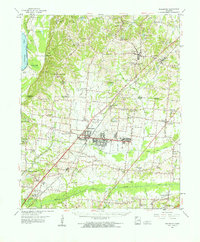
 1969 Mason1969 Print · USGSWest Tennessee in the late sixties reveals a landscape of rural junctions and evolving infrastructure across Tipton, Shelby, and Fayette counties. Genealogists can trace family names at Dunlap Orphanage or local schools like Bloomington Sch and St Mathews Sch.
End of results
Showing maps 1-8 of 8
Top cities near Lakeland
- Memphis historical maps
- Bartlett historical maps
- Collierville historical maps
- Germantown historical maps
- Millington historical maps
- Oakland historical maps
See more
Frequently asked questions
- What are the different types of historical maps available for Lakeland?
- What is the oldest map of Lakeland?
- Where can I purchase historical maps of Lakeland for my home or office?
- Where can I download high-res historical maps of Lakeland?
- Are there historical topographic maps available for Lakeland?
- Is there historical aerial imagery available for Lakeland?
- Where are historical maps of Lakeland sourced from?