1960 Map of Bartlett
USGS Topo · Published 1963About this map
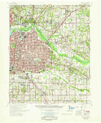
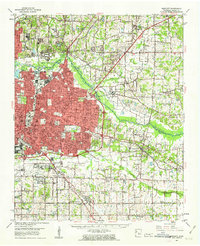
Memphis Municipal Airport and the neighboring U.S. Air Reserve Flying Center anchor the southern portion of this landscape, which transitioned rapidly from agricultural land to suburban density during the mid-century. Residential development pushes eastward from the city core toward Bartlett, while the Shelby County Penal Farm occupies a significant tract along the Wolf River. The map captures a moment of institutional expansion, featuring educational landmarks like Southwestern University and Siena College, alongside military infrastructure at the Memphis General Depot U.S. Army. Rural character persists in the east near Cordova and Forest Hill, where numerous small country churches and cemeteries, such as Polks Chapel and Galilee Memorial Garden, remain prominent. The Louisville and Nashville railroad cuts diagonally through the terrain, connecting established settlements like Germantown to the growing metropolitan network.
Find a feature on this map
71 named features on this map. Tap any name to fly to it.
Don’t see what you’re looking for? This feature index may not catch every label — zoom into the map to look around manually.
Map Details
Editions of this 1960 Bartlett Map
This is the sole edition of this map. No revisions or reprints were ever made.