
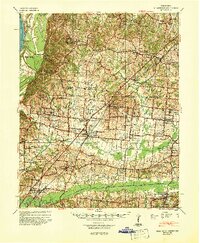
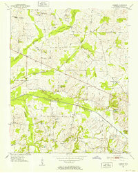
1943 Map of Collierville
USGS Topo · Published 1964About this map
Collierville stands as a primary hub of activity along the Southern line during this wartime era, marking the transition between the agricultural lands of Shelby and Fayette counties. The landscape is defined by the east-west flow of the Wolf River, which is flanked by a dense network of country churches and community schools that reveal the social geography of the 1940s. Of particular historical significance is the Augusta Rosenwald Sch north of the river, representing a specific era of rural education infrastructure.
Find a feature on this map
80 named features on this map. Tap any name to fly to it.
Don’t see what you’re looking for? This feature index may not catch every label — zoom into the map to look around manually.
Map Details
Editions of this 1943 Collierville Map
This is the sole edition of this map. No revisions or reprints were ever made.
Other maps of this area
1942 · Millington
USGS Topo · 1:62,500
1944 · Hernando
USGS Topo · 1:62,500
1948 · Byhalia
USGS Topo · 1:62,500
1949 · Moscow
USGS Topo · 1:62,500
1952 · Lambert
USGS Topo · 1:24,000
1952 · Stanton
USGS Topo · 1:62,500
1953 · Holly Springs
USGS Topo · 1:62,500

1953 · Collierville
USGS Topo · 1:50,000

1954 · Mason
USGS Topo · 1:62,500

1956 · Blytheville
USGS Topo · 1:250,000