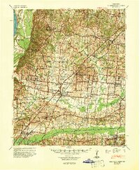
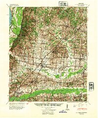
1942 Map of Millington
USGS Topo · Published 1944About this map
Millington and the surrounding borderlands of Tipton County and Shelby County are shown here as they appeared during the early 1940s. The landscape is defined by a dense network of country schools and churches that served as the anchors of rural life, from Williams Chapel School & Cem to the Bolton Agricultural High School. The eastern portion of the map is dominated by a systematic drainage system, including a long Canal and straightened stretches of Big Creek, while the western edge is shaped by the shifting course of the Mississippi River near Neallanding. Transport is anchored by the Illinois Central and Louisville and Nashville railroads, which connect agricultural hubs like Atoka, Kerrville, and Brunswick. This survey documents a critical moment in the region's development, balancing river-bottom geography with established upland farming communities.
Find a feature on this map
116 named features on this map. Tap any name to fly to it.
Don’t see what you’re looking for? This feature index may not catch every label — zoom into the map to look around manually.
Map Details
Editions of this 1942 Millington Map
2 editions found
Other maps of this area

1916 · Memphis
USGS Topo · 1:62,500

1925 · Memphis
USGS Topo · 1:48,000

1927 · Memphis
USGS Topo · 1:62,500

1931 · Jericho
USGS Topo · 1:62,500

1939 · Jericho
USGS Topo · 1:62,500
1939 · Memphis
USGS Topo · 1:62,500

1939 · Evadale
USGS Topo · 1:62,500

1943 · Collierville
USGS Topo · 1:62,500

1952 · Jericho
USGS Topo · 1:62,500

1953 · Collierville
USGS Topo · 1:50,000