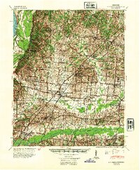
1942 Map of Millington
USGS Topo · Published 1954About this map
The Mississippi River defines the western edge of this wartime survey, carving a complex landscape of backwaters like the Chute of Island No 35 and McLaughlin Lake. East of the river bluffs, the terrain transitions into the agricultural uplands of Shelby and Tipton Counties. The town of Millington serves as a central hub, anchored by the Illinois Central railroad and Millington High School. The map reveals a dense network of rural infrastructure, including numerous small congregations such as Canaan Baptist Church and St James Church & Cem. To the south, the Loosahatchie River is paralleled by a major Drainage Canal, reflecting mid-century efforts to manage the wetlands. Educational landmarks like the Bolton Agricultural High School and smaller rural centers like Rosemark and Barretville illustrate the distributed nature of the region's early 20th-century community life.
Find a feature on this map
79 named features on this map. Tap any name to fly to it.
Don’t see what you’re looking for? This feature index may not catch every label — zoom into the map to look around manually.
Map Details
Editions of this 1942 Millington Map
2 editions found
Other maps of this area

1916 · Memphis
USGS Topo · 1:62,500

1925 · Memphis
USGS Topo · 1:48,000

1927 · Memphis
USGS Topo · 1:62,500

1931 · Jericho
USGS Topo · 1:62,500

1939 · Jericho
USGS Topo · 1:62,500

1939 · Memphis
USGS Topo · 1:62,500

1939 · Evadale
USGS Topo · 1:62,500

1942 · Millington
USGS Topo · 1:62,500

1943 · Collierville
USGS Topo · 1:62,500

1952 · Jericho
USGS Topo · 1:62,500