1960s Maps of Smith County, Tennessee
Explore 8 historic maps of Smith County from the 1960s. These maps offer a rare glimpse into what life looked like during the 1960s — showing old roads, neighborhoods, homes, and landmarks that have changed or disappeared over time.
Whether you're researching your family's past, planning a metal detecting trip, or studying how Smith County's landscape evolved across the 1960s, these high-resolution maps are a powerful tool for exploring the history of this region.
- Focus on a specific era: All maps on this page are from the 1960s, giving you a focused view of this time period.
- See what’s changed: Compare century-old streets, trails, and buildings to today's modern landscape using overlays and satellite layers.
- Research with precision: Use these maps for genealogy, historical research, land use analysis, or educational projects.
- View, download, or print: Maps are fully viewable online in high resolution, and can be downloaded or printed for your own records.
Start exploring Smith County's history through authentic maps from the 1960s. This is your window into the past.
Smith County, TN maps
(8)- 1962 Map of Liberty, 1964 Print
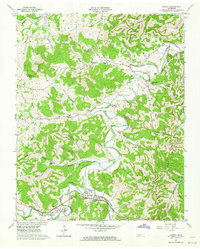 1962 Liberty1964 Print · USGSThe rural communities of DeKalb County are captured in the early sixties as they navigated the transition between traditional valley farming and new reservoir management. Researchers can locate dozens of family burial grounds and churches like Cooper Chapel and Gwaltney Cem, or trace the winding course of the Smith Fork.3 unique versions available
 - 1962 Map of Buffalo Valley, 1964 Print
 1962 Buffalo Valley1964 Print · USGSUpper Middle Tennessee in the early sixties was a landscape of river-bend bottoms and tight ridge-top settlements. Genealogists and historians can trace family land across Caney Fork and Lancaster, or locate old landmarks like Harris Chapel and Maddux Cem.3 unique versions available
 - 1962 Map of Center Hill Dam, 1964 Print
 1962 Center Hill Dam1964 Print · USGSDeKalb County and the surrounding ridges are shown in the early sixties as the Center Hill Reservoir redefined the landscape. Trace local family history through landmarks like Tucker Ridge Ch, Braswell Cem, and the Tennessee Central RR.4 unique versions available
 - 1962 Map of Gordonsville, 1964 Print
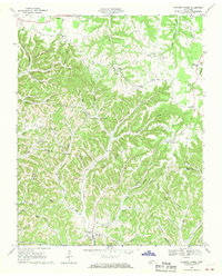
 1962 Gordonsville1964 Print · USGSSmith County is shown in the early sixties as a region of winding river bends and hillside farms connected by the Tennessee Central railroad. Genealogists can trace family names through dozens of sites like Baird Memorial Cem, Ducktown Ch, and Old Middleton.3 unique versions available
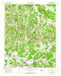
 - 1968 Map of Willette, 1970 Print
 1968 Willette1970 Print · USGSThe hills of Jackson and Macon counties are shown here in the late sixties just before the landscape was changed by the Cordell Hull Reservoir. Genealogists can trace family sites like Thomas Cem, Hayden, and the Wartrace Sch among the winding hollows.
 - 1968 Map of Pleasant Shade, 1970 Print
 1968 Pleasant Shade1970 Print · USGSUpper Middle Tennessee in the late sixties reveals a landscape of family-run farms and ridge-top communities at the junction of Macon and Smith counties. Genealogists can trace family names through landmarks like Butler Cem, Ebenezer Ch, and the small settlement of Pleasant Shade.2 unique versions available
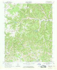
 - 1968 Map of Granville, 1970 Print
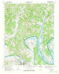
 1968 Granville1970 Print · USGSJackson and Smith County river life is captured here as the Cordell Hull Reservoir begins to shape the valley. Trace family sites and land ownership near Granville, Kempville, and the many cemeteries tucked into Stillhouse Hollow.3 unique versions available
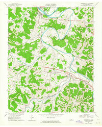
 - 1968 Map of Carthage, 1970 Print
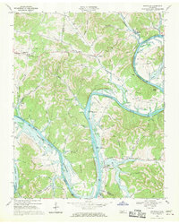
 1968 Carthage1970 Print · USGSCarthage and the Cumberland River valley are captured here in the late sixties during the creation of the Cordell Hull Reservoir. Researchers can trace family sites near Monoville and Difficult, or locate rural landmarks like Cornwell Chapel and Goodall Island.2 unique versions available
End of results
Showing maps 1-8 of 8
Top cities of Smith County
Frequently asked questions
- What are the different types of historical maps available for Smith County?
- What is the oldest map of Smith County?
- Where can I purchase historical maps of Smith County for my home or office?
- Where can I download high-res historical maps of Smith County?
- Are there historical topographic maps available for Smith County?
- Is there historical aerial imagery available for Smith County?
- Where are historical maps of Smith County sourced from?