1900s (20th Century) Maps of Smith County, Tennessee
Explore 26 historic maps of Smith County from the 1900s (20th Century). These maps offer a rare glimpse into what life looked like during the 1900s — showing old roads, neighborhoods, homes, and landmarks that have changed or disappeared over time.
Whether you're researching your family's past, planning a metal detecting trip, or studying how Smith County's landscape evolved across the 1900s, these high-resolution maps are a powerful tool for exploring the history of this region.
- Focus on a specific era: All maps on this page are from the 1900s, giving you a focused view of this time period.
- See what’s changed: Compare century-old streets, trails, and buildings to today's modern landscape using overlays and satellite layers.
- Research with precision: Use these maps for genealogy, historical research, land use analysis, or educational projects.
- View, download, or print: Maps are fully viewable online in high resolution, and can be downloaded or printed for your own records.
Start exploring Smith County's history through authentic maps from the 1900s. This is your window into the past.
Smith County, TN maps
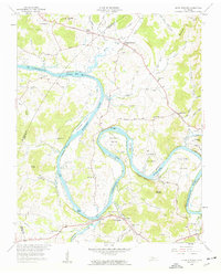
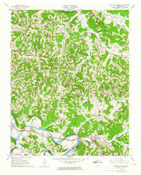
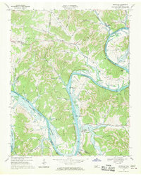
(26)- 1928 Map of Gordonsville
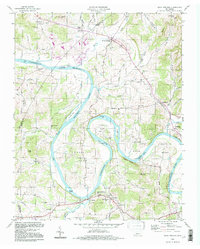
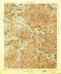 1928 Gordonsville1928 Print · USGSMiddle Tennessee in the late twenties was a landscape defined by the winding bends of the Caney Fork and the rise of rural river settlements. Genealogists can locate family-named landmarks like Walker Creek Sch and Hurst Chapel, or trace old river crossings at Greenmoos Ferry and Loves Ferry.2 unique versions available
 - 1932 Map of Carthage
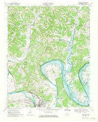
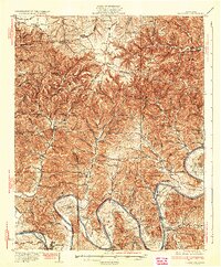 1932 Carthage1932 Print · USGSNorth Central Tennessee comes alive in the early 1930s as the Cumberland River winds past the county seat of Carthage. Genealogists and researchers can trace family roots through numerous country schools and landmarks like Holliman Ferry and Difficult.3 unique versions available
 - 1942 Map of Statesville
 1942 Statesville1942 Print · USGSMid-century Tennessee comes alive in this survey of the river valleys and rail lines east of Nashville. Researchers can trace the path of the Tennessee Central Railway and locate historic points like Denny Seminary and Tuckers Crossroads.
 - 1956 Map of Corbin, 1966 Print
 1956 Corbin1966 Print · USGSThe Kentucky and Tennessee borderlands are captured here in the mid-fifties, showing the region's shift toward modern interstate travel and reservoir development. Genealogists and historians can trace old community lines near Albany and Monticello or locate early rail junctions along the Southern and Tennessee Central lines.3 unique versions available
 - 1956 Map of Nashville, 1971 Print
 1956 Nashville1971 Print · USGSThe Tennessee-Kentucky borderlands come into focus in the mid-1960s as major reservoir projects transformed the Cumberland and Tennessee river valleys. Researchers can trace the rail networks of the Louisville and Nashville and visit sites like Fort Campbell and Fort Donelson National Military Park.2 unique versions available
 - 1958 Map of New Middleton
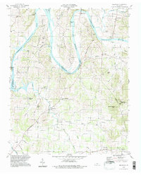
 1958 New Middleton1958 Print · USGSSmith and Wilson counties in the late fifties show a landscape of steep knobs and winding creek bottoms. Genealogists and historians can trace family locations through numerous sites like Bethlehem Cem, the Tennessee Central rail line, and New Middleton.4 unique versions available
 - 1958 Map of Corbin
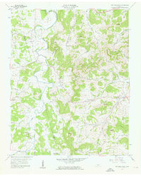
 1958 Corbin1958 Print · USGSThe Upper Cumberland borderlands appear in the late 1950s as massive reservoirs and early atomic-era growth reshape the region. Trace family roots and vanished landmarks near Lake Cumberland, Oak Ridge, and the Cumberland National Forest.
 - 1958 Map of Bellwood, 1959 Print
 1958 Bellwood1959 Print · USGSWilson County in the late fifties shows a rural landscape shaped by the winding Cumberland River and the newer waters of Old Hickory Lake. Genealogists can locate family landmarks like Tomlinson Cem, Wier Cem, and the Conway Sch in the hills near Centerville.3 unique versions available
 - 1958 Map of Dixon Springs, 1959 Print
 1958 Dixon Springs1959 Print · USGSThe Cumberland River valley in north-central Tennessee is captured here during the 1950s as the river began its transformation into a reservoir. Local historians can trace old community hubs like Dixon Springs, Rome, and schools such as Union Heights Sch and Cox-Davis Sch.4 unique versions available
 - 1958 Map of Alexandria, 1959 Print
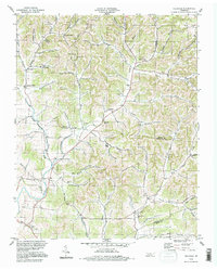
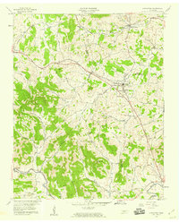 1958 Alexandria1959 Print · USGSMid-century Tennessee hill country comes alive here as the Tennessee Central railroad tracks connect Alexandria and Watertown. Genealogists and historians can trace family roots at Old Caney Fork Cem or locate Upper Helton Ch near the banks of Hickman Creek.3 unique versions available
 - 1959 Map of Nashville
 1959 Nashville1959 Print · USGSMiddle Tennessee and Southern Kentucky come into focus during the late fifties, showing the region's transition into a modern transportation and military hub. Researchers can trace the sprawling Fort Campbell Military Reservation or locate historic rail stops along the Tennessee Central Ry and Illinois Central RR.
 - 1959 Map of Hillsdale, 1960 Print
 1959 Hillsdale1960 Print · USGSMacon and Trousdale counties come into focus during the late fifties, showcasing a rural Tennessee landscape defined by narrow hollows and ridge-top roads. Genealogists can trace family names through dozens of landmarks like Wilburn Cem, Stafford Cem, and the community of New Harmony.2 unique versions available
 - 1962 Map of Liberty, 1964 Print
 1962 Liberty1964 Print · USGSThe rural communities of DeKalb County are captured in the early sixties as they navigated the transition between traditional valley farming and new reservoir management. Researchers can locate dozens of family burial grounds and churches like Cooper Chapel and Gwaltney Cem, or trace the winding course of the Smith Fork.3 unique versions available
 - 1962 Map of Buffalo Valley, 1964 Print
 1962 Buffalo Valley1964 Print · USGSUpper Middle Tennessee in the early sixties was a landscape of river-bend bottoms and tight ridge-top settlements. Genealogists and historians can trace family land across Caney Fork and Lancaster, or locate old landmarks like Harris Chapel and Maddux Cem.3 unique versions available
 - 1962 Map of Center Hill Dam, 1964 Print
 1962 Center Hill Dam1964 Print · USGSDeKalb County and the surrounding ridges are shown in the early sixties as the Center Hill Reservoir redefined the landscape. Trace local family history through landmarks like Tucker Ridge Ch, Braswell Cem, and the Tennessee Central RR.4 unique versions available
 - 1962 Map of Gordonsville, 1964 Print
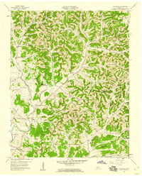
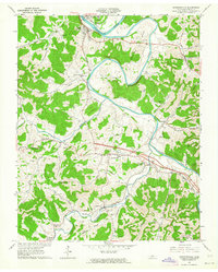 1962 Gordonsville1964 Print · USGSSmith County is shown in the early sixties as a region of winding river bends and hillside farms connected by the Tennessee Central railroad. Genealogists can trace family names through dozens of sites like Baird Memorial Cem, Ducktown Ch, and Old Middleton.3 unique versions available
 - 1968 Map of Willette, 1970 Print
 1968 Willette1970 Print · USGSThe hills of Jackson and Macon counties are shown here in the late sixties just before the landscape was changed by the Cordell Hull Reservoir. Genealogists can trace family sites like Thomas Cem, Hayden, and the Wartrace Sch among the winding hollows.
 - 1968 Map of Pleasant Shade, 1970 Print
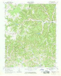
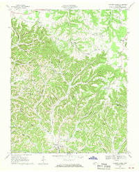 1968 Pleasant Shade1970 Print · USGSUpper Middle Tennessee in the late sixties reveals a landscape of family-run farms and ridge-top communities at the junction of Macon and Smith counties. Genealogists can trace family names through landmarks like Butler Cem, Ebenezer Ch, and the small settlement of Pleasant Shade.2 unique versions available
 - 1968 Map of Granville, 1970 Print
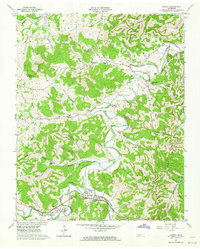
 1968 Granville1970 Print · USGSJackson and Smith County river life is captured here as the Cordell Hull Reservoir begins to shape the valley. Trace family sites and land ownership near Granville, Kempville, and the many cemeteries tucked into Stillhouse Hollow.3 unique versions available
 - 1968 Map of Carthage, 1970 Print
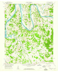
 1968 Carthage1970 Print · USGSCarthage and the Cumberland River valley are captured here in the late sixties during the creation of the Cordell Hull Reservoir. Researchers can trace family sites near Monoville and Difficult, or locate rural landmarks like Cornwell Chapel and Goodall Island.2 unique versions available
 - 1982 Map of Cookeville, 1983 Print
 1982 Cookeville1983 Print · USGSThe Upper Cumberland region comes into focus during the early eighties as Cookeville and its surrounding counties adapt to new reservoirs and highways. Researchers can trace the Louisville and Nashville rail line and locate landmarks like Tennessee Technological University and Standing Stone State Forest.
 - 1984 Map of Nashville, 1985 Print
 1984 Nashville1985 Print · USGSMiddle Tennessee in the mid-1980s reveals a region balancing urban expansion with its deep river-valley roots. Genealogists and historians can trace family locations near Old Hickory Lake, explore the grounds of Vanderbilt University, or locate ancestral sites like Greenwood Cem.
 - 1994 Map of Bellwood, 1997 Print
 1994 Bellwood1997 Print · USGSThe river bends and rural uplands of the Wilson and Trousdale county lines are shown here during the late twentieth century. Researchers can trace family sites from Centerville to Taylorsville, alongside landmarks like Dickerson Chapel and Tomlinson Cem.
 - 1994 Map of Hillsdale, 1997 Print
 1994 Hillsdale1997 Print · USGSThe rural borders of Macon and Trousdale counties come into focus in the mid-1990s, revealing a landscape of family-named hollows and ridge-top settlements. Genealogists and local researchers can trace historic community hubs like Hillsdale, Horsleys, and Beech Hill alongside numerous unnamed cemeteries and local landmarks.
 - 1994 Map of Dixon Springs, 1997 Print
 1994 Dixon Springs1997 Print · USGSThe Cumberland River bends through Smith County in the 1990s, where reservoir waters have reshaped the valley floor. Genealogists can locate family landmarks like Piper-Hughes Cem, Chapel Hill Ch, and the rural settlement of Dixon Springs.
Showing maps 1-25 of 26
Top cities of Smith County
Frequently asked questions
- What are the different types of historical maps available for Smith County?
- What is the oldest map of Smith County?
- Where can I purchase historical maps of Smith County for my home or office?
- Where can I download high-res historical maps of Smith County?
- Are there historical topographic maps available for Smith County?
- Is there historical aerial imagery available for Smith County?
- Where are historical maps of Smith County sourced from?