1960s Maps of Stewart County, Tennessee
Explore 5 historic maps of Stewart County from the 1960s. These maps offer a rare glimpse into what life looked like during the 1960s — showing old roads, neighborhoods, homes, and landmarks that have changed or disappeared over time.
Whether you're researching your family's past, planning a metal detecting trip, or studying how Stewart County's landscape evolved across the 1960s, these high-resolution maps are a powerful tool for exploring the history of this region.
- Focus on a specific era: All maps on this page are from the 1960s, giving you a focused view of this time period.
- See what’s changed: Compare century-old streets, trails, and buildings to today's modern landscape using overlays and satellite layers.
- Research with precision: Use these maps for genealogy, historical research, land use analysis, or educational projects.
- View, download, or print: Maps are fully viewable online in high resolution, and can be downloaded or printed for your own records.
Start exploring Stewart County's history through authentic maps from the 1960s. This is your window into the past.
Stewart County, TN maps
(5)- 1965 Map of Needmore, 1966 Print
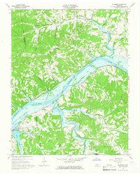 1965 Needmore1966 Print · USGSThe Cumberland River valley in the mid-sixties shows the impact of the newly created Lake Barkley on the Tennessee landscape. Local historians can trace the route of the Louisville and Nashville Railroad through rural communities like Needmore, Sailors Rest, and Corbandale.3 unique versions available
 - 1965 Map of Erin, 1966 Print
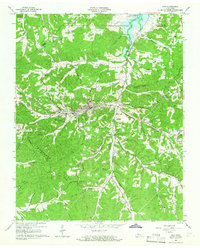 1965 Erin1966 Print · USGSThe Houston County seat of Erin and the surrounding Tennessee hills are shown here in the mid-sixties as Lake Barkley took its final shape. Genealogists and local historians can trace family roots through landmarks like Mt Sinai Ch, Secret Prayer Ch, and the rural community of Haggieville.3 unique versions available
 - 1965 Map of Cumberland City, 1966 Print
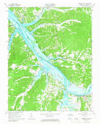 1965 Cumberland City1966 Print · USGSStewart County's riverfront was undergoing a major transformation in the mid-sixties with the creation of Lake Barkley. Genealogists can trace family landmarks like Throckmorton, Dunbar Chapel, and the Louisville and Nashville rail line near Cumberland City.3 unique versions available
 - 1965 Map of Ellis Mills, 1966 Print
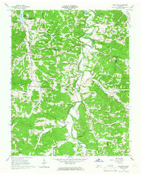 1965 Ellis Mills1966 Print · USGSHouston and Montgomery counties come together in the mid-1960s among the hollows and creek valleys feeding into the Cumberland River. Researchers can trace rural lineages through sites like Griffin Chapel, Ellis Mills, and the Cedar Hill Cem.3 unique versions available
 - 1967 Map of Linton, 1970 Print
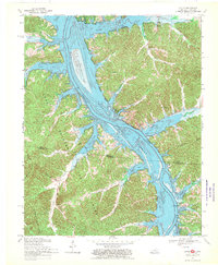 1967 Linton1970 Print · USGSThe Kentucky and Tennessee borderlands appear here in the late sixties as the newly formed Lake Barkley reshaped the river valley. Researchers can trace the layout of Linton, Model, and Tobaccoport alongside landmarks like Big Joe Spring and Fox Ridge.2 unique versions available
End of results
Showing maps 1-5 of 5
Top cities of Stewart County
Frequently asked questions
- What are the different types of historical maps available for Stewart County?
- What is the oldest map of Stewart County?
- Where can I purchase historical maps of Stewart County for my home or office?
- Where can I download high-res historical maps of Stewart County?
- Are there historical topographic maps available for Stewart County?
- Is there historical aerial imagery available for Stewart County?
- Where are historical maps of Stewart County sourced from?